


You are using an out of date browser. It may not display this or other websites correctly.
You should upgrade or use an alternative browser.
You should upgrade or use an alternative browser.
Trail Map
- Thread starter Jason
- Start date


From Space:
This is the MOST up to dat map at this point:
http://www.mtbnj.com/forum/attachment.php?attachmentid=2321&d=1231955131
This is the MOST up to dat map at this point:
http://www.mtbnj.com/forum/attachment.php?attachmentid=2321&d=1231955131
Last edited:
Wobbegong
Well-Known Member
I've been working on this for a while. Here is a current map of the twisty section on the Rt.27 side. I didnt highlight all of the outer access trails, as many are overgrown and dont go anywhere useful. This is from GPS data, some is drawn in from a mix of rides I did to get it all. Hope this helps.
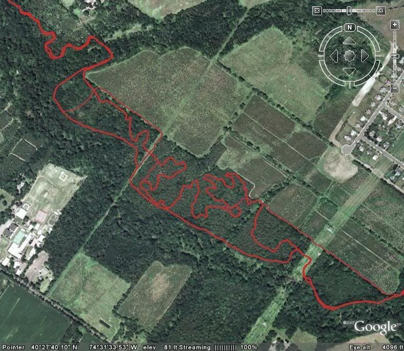
I've been working on this for a while. Here is a current map of the twisty section on the Rt.27 side. I didnt highlight all of the outer access trails, as many are overgrown and dont go anywhere useful. This is from GPS data, some is drawn in from a mix of rides I did to get it all. Hope this helps.
this is great - thanks for putting this together.
warcricket
Like a Jerk
this is actually really fun to look at!
now all that's left is to name them...
now all that's left is to name them...
GSTim
Formerly M3Tim
J,
This is really great, What would be really fun would be to annotate this with landmarks or features so that you can get a feel for where these are on the trails. (i.e. Steep uphill where you take the outside line around the tree while not falling off the cliff 😀)
Tim
This is really great, What would be really fun would be to annotate this with landmarks or features so that you can get a feel for where these are on the trails. (i.e. Steep uphill where you take the outside line around the tree while not falling off the cliff 😀)
Tim
Last edited:
Ian F
Well-Known Member
I've been working on this for a while. Here is a current map of the twisty section on the Rt.27 side. I didnt highlight all of the outer access trails, as many are overgrown and dont go anywhere useful. This is from GPS data, some is drawn in from a mix of rides I did to get it all. Hope this helps.
Could somebody please e-mail this one and jdog's to me? ifurqueron@ipsdb.com
Unfortunately, photobucket is a blocked site for me at work so the pitcures show up as red X's. 🙁
BiknBen
Well-Known Member
Could somebody please e-mail this one and jdog's to me? ifurqueron@ipsdb.com
I'm on it...give me a moment.
Update:
Message sent with attachments @ 10:05am
Last edited:
Ian F
Well-Known Member
Got 'em! thanks! 😀
Yowzers! I didn't realize there was so much on the other side of South Middlebush Road! 😱 I'm really looking forward to checking this out now.
Curious... does anyone ever start rides from Canal Road? Tends to be much easier for me to get to after work than the often traffic-clogged Rt 27. although Rt 27 won't be a problem for morning w/e rides.
side note: laser color printers rock!
Got 'em! thanks! 😀
Yowzers! I didn't realize there was so much on the other side of South Middlebush Road! 😱 I'm really looking forward to checking this out now.
Curious... does anyone ever start rides from Canal Road? Tends to be much easier for me to get to after work than the often traffic-clogged Rt 27. although Rt 27 won't be a problem for morning w/e rides.
side note: laser color printers rock!
some people start on the canal, just a different flow since the canal side is fast and not nearly as twisty.
warcricket
Like a Jerk
i start from the canal majority of the time and take the blue out, do 27, and take red back.
however i do think the better ride starts from the 27 side, because hitting the blue first makes me feel slow... idk.
however i do think the better ride starts from the 27 side, because hitting the blue first makes me feel slow... idk.
Wobbegong
Well-Known Member
Interesting... I thought the red trail was "no bikes"? 😕
With any luck, I'm going to get out there Monday. 🙂
Biking is illegal on the red trail, this should change soon with the upcoming trail work being done on the red trail. For now, it's illegal to ride.
Biking is illegal on the red trail, this should change soon with the upcoming trail work being done on the red trail. For now, it's illegal to ride.
The red trail is like Gay Dudes in the Navy.
j-
The red trail is like Gay Dudes in the Navy.
j-
what does fred have to do with the red trail?
http://en.wikipedia.org/wiki/DADT
In exchange for building a bunch of new trails we will in return be allowed to legalize the red trail.
In exchange for building a bunch of new trails we will in return be allowed to legalize the red trail.
Last edited:
warcricket
Like a Jerk
yea, i ment i hike the red trail back
alex_k
Well-Known Member
The Kalmyk
Well-Known Member
Your route looks longer than 11 miles 😕