Round Valley Conditions

Patrick

Overthinking the draft from the basement already
Staff member
Beavers

I finally find Waldo and he pranks me.
R/W streamers - not sure if it is hunters ( bait, tree, and blind set up northeast of back gate) or someone just marking the trail

5AC3644B-CC35-4C91-84E0-063C86AD12E8.jpeg
 

Patrick

Overthinking the draft from the basement already
Staff member
Why you taking out all the features? Trees are fun.

less fun at neck high - so i bring them down to trail level and pile a bunch of sticks to make a ramp from the uphill side.
it is impossible to clear riding uphill, but nobody does that.

as an aside, i usually cut them and leave a log-over + go around. cause that is how i roll.
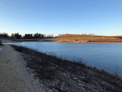
 

goldsbar

Well-Known Member
You need to take the logs out with all of the newbies swarming around this place. Can hardly ride here anymore.
 

Fire Lord Jim

Well-Known Member
Rode in from Cushetunk lot and down to the bottom of the dam by the youth center. Conditions were great everywhere except for the new trail around the youth center, which was thawing and will be a mess when warm.
 

Eschmitt85

New Member
Rode just about everything today and the ground was nicely frozen and firm. On our way out the new section by the youth center was just starting to thaw a bit where the sun was hitting it.
7BD2B11B-0F1B-430D-A526-81F62A11EDD9.jpeg
 

THATmanMANNY

Well-Known Member
naive me. I really thought the snow woulda been melted by now. The ice is from the hikers packing it in. My bro and I rode up the road to the main entrance to try and find the trail from the west dock area. Couldn’t even see the trail. So we rode the “beach” back. The water is probably like 20’ lowz. It was interesting terrain. Is this what Mars will be like? Still beautiful to get out.
E536BD69-21B7-478C-8D60-A3538B1046F5.jpeg

066246EF-7F07-4134-A910-1D66A79AC0C2.jpeg
 

Patrick

Overthinking the draft from the basement already
Staff member
RV is ready to go.
The worst part is the double track between the scuba lot and the south dam access road. Couple of trees at head height in the switchbacks and some mud in the new section.
a little snow left in the shade but mostly avoidable. Cush is good too. Have at it.
i didn’t ride the ridge, and I’d expect the link to pickel park to be sloppy.
 

terrabike01

Well-Known Member
RV is ready to go.
The worst part is the double track between the scuba lot and the south dam access road. Couple of trees at head height in the switchbacks and some mud in the new section.
a little snow left in the shade but mostly avoidable. Cush is good too. Have at it.
i didn’t ride the ridge, and I’d expect the link to pickel park to be sloppy.
You would have thought they would have did a better job building that new section instead of just clearing the ground and leaving the topsoil. That trail going to be permanent?
 

Patrick

Overthinking the draft from the basement already
Staff member
You would have thought they would have did a better job building that new section instead of just clearing the ground and leaving the topsoil. That trail going to be permanent?

I'm going to guess permanent, given all the changes - there is a retention basin where the old trail was.

there is one "bad" spot - and the rest is generally soft, with grass - which won't survive the spring.
Not sure if there is a good solution other than improve the trail bed - and not sure what that means for a relatively flat trail.
 

johnnyrides

Active Member
Never been to RV. Where should I park and what loop or path do you recommend? Intermediate rider here. Thanks for any suggestions.
 

Patrick

Overthinking the draft from the basement already
Staff member
Never been to RV. Where should I park and what loop or path do you recommend? Intermediate rider here. Thanks for any suggestions.

Park in the cushetunk lot - if it is full, there are spots across the railroad tracks.

About 25yards past the kiosk, up the powerline cut is the trailhead.
This is important - cause the other trail is closed until august, and you'd never want to ride up that anyway
(down is crazy!)

There isn't that much tech - it is mostly climbing, and descending.

I went around the res yesterday, because i ran out of time. Usually i do an out-n-back,
and include the ridge trail -

Yesterday

I didn't start the computer in the lot - but there is a right turn .4 of this ride that makes the climb up cush more tolerable -
It is the "Zee climb" on strava. https://www.strava.com/activities/1147024533/segments/28255512625

Usually do something like

at mile 1.5 of this ride, go down the hill towards the water, not up - it doesn't ride well at all in that direction.

there is a campground road along the water, if the return trip starts to hurt too much ;)

also, with the water down, riding the rocks on the "beach" is fun - lots of features.
 
Last edited:

terrabike01

Well-Known Member
I'm going to guess permanent, given all the changes - there is a retention basin where the old trail was.

there is one "bad" spot - and the rest is generally soft, with grass - which won't survive the spring.
Not sure if there is a good solution other than improve the trail bed - and not sure what that means for a relatively flat trail.
You would have thought with the gazillion dollars they are spending they would have dug out the topsoil and put a good QP base down to make a good solid year round trail. That's going to be a slop fest year round.
 

Trail Conditions

Current Conditions

powered by Trailforks.com
Top Bottom