Kaleidopete
Well-Known Member
The early worm gets the bird!View attachment 130219
Been stalking this bird for two weeks and finally, by luck, got this photo just after 7:14am.


The early worm gets the bird!View attachment 130219
Been stalking this bird for two weeks and finally, by luck, got this photo just after 7:14am.


According to strava I surpassed 20K miles on my road bike since I bought it back in aug 2016.
Thanks. Been a few good years of riding so now that new job is also WFH I might be able to continue the trend.Keep it going man!
Look at all them jumps!Met up with @jklett, @Paul H, and Di (now from Sourland Cycles)
for a little 6MR journey - celebrated with a beer afterwards! Thanks Jay
View attachment 130476
Met up with @jklett, @Paul H, and Di (now from Sourland Cycles)
for a little 6MR journey - celebrated with a beer afterwards! Thanks Jay
View attachment 130476
Look at all them jumps!
View attachment 130482
No group hugs were involved 😛wrong thread - this should be posted in the "we're not social distancing" thread!
yeah maybe it is that dirt road "Featherbed" off top of zion - that goes really close to the pipeline
Sorry, been AWOL. Not 100% what you're looking for, but if you want an adventure, go down Pirozzi Ln. Last driveway on the left, turn right into the brush. You can ride that across to Montgomery, cross Montgomery to N Hill and finally to Montgomery. I thought I was going to get shot at N Hill my first time there; homeowners there feel like isolationists/nationalists. Follow the pipeline out to fields, turn left at the start of the fields, cut down the first split in the fields and you'll make it to the road (muddy AF here, expect to sink). Go left up Lindbergh to Ridge Road, jump in the Sourland Mountain Reserve, hook up that with a bushwack to Hunterdon County Sourlands (all rideable, follow the side of the stream beds) cross Rileyville, and you can find deer trails and get to Amwell Lake WMA. That's where I have stopped - so close to Water Co. Be prepared with tools, water and tubes. It's a long ride physically and mentally. I'll connect it to Lambertville. Just need a little more time to explore. My advice - if you think you see a trail, take it. That's as good as it gets in some spots.
Give it a shot. Stay outta sight and low key. I'm not sure who owns what land parcels. Don't Strava it please!
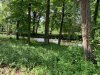
Great weather this morning.
Nice trail
View attachment 130587
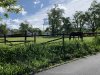
Mama & baby deer, baby took off running
View attachment 130588
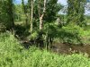
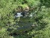
Egg laying time
View attachment 130589
All my years and all my trails, never came across a turtle like that 🙁I wasn’t looking for eggs, but there were a couple of these on the trails of Hartshorne and Huber today.
View attachment 130653View attachment 130654
Depending on where you are starting from in Flemington, this might be worth a try, it's mostly quiet roads, some dirt & some bushwhacking. From the junction of Old York Rd and Cloverhill Rd head across the fields to Three Bridges Rd; you can exit the fields at the parking lot near the small pond or there is a lane that goes down to 3 Bridges Rd just east of it's junction with Higginsville Rd. There are some old roads thru those fields & look for the eagle's nest in the pylon across the river. Cross over the river on Higginsville Rd and take the railtrail to Woodfern Road. Then take Woodfern in to Neshanic Station, over the river and right on River Rd to Amwell Rd. (You might be able to ride the trail along the river from Blackpoint Rd in to NS, but I don't know, haven't checked it). Go east on Amwell a short distance and take the first right on to Miller Lane. Note - there's a sign there that says Private Road, but I'm pretty sure Ranger Chris said it was not private. I could be wrong, but either way I explored it a few years ago without problem, YMMV. This is where the adventure/bushwhacking begins, you need to make your way to devil's half acre. I used to ride a loop up there some years ago (up until the red trail was built, whenever that was) starting from devil's half acre going north to the water tower and back but I'm sure that trail will be overgrown by now, there also used to be the remnants an old boy scout trail that could be followed in places.Thanks for the tips. I'm trying to find a direct way to get from my place in Flemington to sourland mountain preserve. Heading straight south gets me to Manners to Wertzville. Looks like on the map I could take wertzville to north hill and then jump on the pipeline clearing to Longhill. Will try that next.