


You are using an out of date browser. It may not display this or other websites correctly.
You should upgrade or use an alternative browser.
You should upgrade or use an alternative browser.
Stephens State Park Conditions
- Thread starter pedals
- Start date
Tally ho is back to its former glory. Very fast and a bit overgrown, but so fun. I haven't been hitting it for a while and I really enjoyed it today.
Trestle is ready for a brush hogging and if I find a day to do it, i'll hit it.
Awesome, so happy to hear that. There's some sightlines I'd love to open up around turns and some berms that need to be built up.
I'm planning on trimming that and trestle this week hopefully now the sinkhole has been closed.
Last edited:
chainsawer
Well-Known Member
Thanks. Nice ride. What means "northern leg of the maze"? Is that in the area where you rode over twice, or was on lower or upper?View attachment 261886
So good up high. Took 2 guys out for a little tour who were blown away with this loop/.
Very wet by the lake.
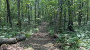
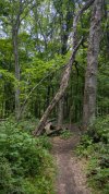
One log down on the northern leg of the maze. I remember on pinch point on Hally Toe and one on Tally Hoe.
Tally ho is back to its former glory. Very fast and a bit overgrown, but so fun. I haven't been hitting it for a while and I really enjoyed it today.
VERY welcome trimming below the mulch. Could use a quick trim of the first 100 feet on the mulch trail.
Trestle is ready for a brush hogging and if I find a day to do it, i'll hit it.
Holy NICA madness today. I stopped by the concert field and said NOPE. Drove up to the station road lot and had and enjoyable ride with my boy up top. White/Golden/Upper Meisterberger were all in great shape.
June 7/8 is NICA race weekend at Stephens. Expect Blue/Green Rock trail areas to be quite crowded all week as local teams try to get in as many race-prep practices as possible.
I think he is referring to this section where I put a red arrow on the attached photo. I also saw the downed tree on my ride Sunday afternoon. The downed tree is close to that arrow, but the arrow is not an exact pinpoint. Wish I could give better intel to you. Sorry that I'm doing this from memory and it's not an exact screenshot.What means "northern leg of the maze"?
For future use, can anyone tell me how to take a screen shot of Trailforks on an Android phone? Thanks!
chainsawer
Well-Known Member
Thanks. On my android, there's three buttons on the right side. the upper one is the screen lock. The lower two control the volume. To take the screenshot, simultaneously press the screen lock and lower volume button. Reminder: In trailforks, press the locator button on the top right of your screen to make sure your curser location is updated.
With both of my Androids so far, if you hit the volume and power button at the same time, it takes a screenshot. Your phone may be differentI think he is referring to this section where I put a red arrow on the attached photo. I also saw the downed tree on my ride Sunday afternoon. The downed tree is close to that arrow, but the arrow is not an exact pinpoint. Wish I could give better intel to you. Sorry that I'm doing this from memory and it's not an exact screenshot.
For future use, can anyone tell me how to take a screen shot of Trailforks on an Android phone? Thanks!
View attachment 261916View attachment 261917
Yes. This.I think he is referring to this section where I put a red arrow on the attached photo. I also saw the downed tree on my ride Sunday afternoon. The downed tree is close to that arrow, but the arrow is not an exact pinpoint. Wish I could give better intel to you. Sorry that I'm doing this from memory and it's not an exact screenshot.
For future use, can anyone tell me how to take a screen shot of Trailforks on an Android phone? Thanks!
View attachment 261916View attachment 261917
chainsawer
Well-Known Member
Just a little note about blowdown reporting here. Maybe this helps.
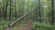
As you already know, the 2 following types of pics are wonderful if you can get 'em; 1.) The screenshot of the location in Trailforks (or other GPS app) and 2.) a pic of the blowdown. That's the super A+++, gold star award, Holy grail of intel.
If you're on a ride with others, I know it's a headache to stop and hold people up. If in a rush, forgo the pic of the blowdown. The GPS location pic is *SO MUCH MORE* important, and quick to execute. A verbal description of the tree will suffice in a pinch, I'm mostly interested in the diameter and a simple description anyway. The pic of the blowdown is more important if it's unusual in some way, more than just the run-of-the-mill 6-12" trunk perpendicular to the trail.
Verbal location descriptions have been kind of hit or miss recently. When choosing my cut plan for the day, I'll opt for targets with solid intel over fuzzy intel.
Thanks again for everyone's help though! Much appreciated!!!
Last edited:
chainsawer
Well-Known Member
I got this one today. Thanks.I think he is referring to this section where I put a red arrow on the attached photo. I also saw the downed tree on my ride Sunday afternoon. The downed tree is close to that arrow, but the arrow is not an exact pinpoint. Wish I could give better intel to you. Sorry that I'm doing this from memory and it's not an exact screenshot.
For future use, can anyone tell me how to take a screen shot of Trailforks on an Android phone? Thanks!
View attachment 261916View attachment 261917
chainsawer
Well-Known Member
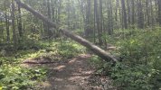
i got this one today. And the Widowmaker behind it! Thanks!!
chainsawer
Well-Known Member
In addition to the targets mentioned above, I cleared 3 juicy widowmakers today... One right at the RR crossing, and two out on green, near the fire tower/gravity cavity area...
Attachments
rjr44
Well-Known Member
Depends on version of android. What @gmb3 suggested will always work. On newer versions easier way for me is just do a slow pull up from bottom of screen and you get something like the below where you can choose screenshot. Once you choose that you can crop, edit, etc.For future use, can anyone tell me how to take a screen shot of Trailforks on an Android phone? Thanks!
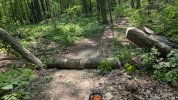
So happy to see the red line in that last pic. Scary one.In addition to the targets mentioned above, I cleared 3 juicy widowmakers today... One right at the RR crossing, and two out on green, near the fire tower/gravity cavity area...
NICA teams don't bite, I promise =pHoly NICA madness today. I stopped by the concert field and said NOPE. Drove up to the station road lot and had and enjoyable ride with my boy up top. White/Golden/Upper Meisterberger were all in great shape.
chainsawer
Well-Known Member
Good eye. That's kevlar linesman rope which helps to encourage unstable widowmakers to fall on their own. I still had to make a saw cut but the rope worked for the dicey part.So happy to see the red line in that last pic. Scary one.
YaGottaBelieve
New Member
The park has been in such great shape this week; the mazes, under the mulch, around the lake, blue rock all freshly trimmed and riding great.
Passed someone doing some trimming on blue rock today! Thank you to all who do trail maintenance!
Passed someone doing some trimming on blue rock today! Thank you to all who do trail maintenance!
Thanks, upcoming NICA race! Kids these days - so spoiled 🙂The park has been in such great shape this week; the mazes, under the mulch, around the lake, blue rock all freshly trimmed and riding great.
Passed someone doing some trimming on blue rock today! Thank you to all who do trail maintenance!
YaGottaBelieve
New Member
Since the new Green Rock Trail was built I've taken that almost exclusively to get back to Kinney, but yesterday I wanted to check in with the downhill flow of the older Blue Rock Trail. My timing was perfect to encounter 20-30 NICA kids heading uphill at me.Thanks, upcoming NICA race! Kids these days - so spoiled 🙂
Happy to see the kids will have great conditions to compete.