Stephens State Park Conditions

I would prefer to think of it as managing them. He can have a 8’ deep pond, just not a 12’ deep pond for example. Open to the general option of the board and or the powers that be.
For example the water levels not only effect the bridge but also encroaching the trail.
IMG_8113.jpeg

You can see the dark black was the high water mark, which negatively impacted the trail as well as the bridge crossing.
 
I'd still vote for coexistence with the beaver and move the bridge on top of the beaver dam. Then we can readjust the trail if it floods.
 
Dennis K & I dropped into Stephens tonight, from the Station road lot. We worked our way over to several issues on the Northern Side of the park, including a big mess on Swamp & Chop,and smaller ones on Long Way Round, Border Trail, Upper Woods road. We then worked our way back to a few small issues on Sunset Trail. Along the way, a few tuneups and cleanups. We intended to finish up on the XX trail, but a mechanical changed that plan. (Lost a spoke and ruined a rear rim). Thanks to Dennis for the help.
 

Attachments

  • Screenshot_20240521-203107.png
    Screenshot_20240521-203107.png
    278 KB · Views: 104
Last edited:
I did the Trifecta TM today. Visited 3 parks to chase after loose ends. Dickerson Mine, then Stephens, then got a big one at Deer Park. At Stephens, I cleared 3 "on the ground" blockages on the "XX" trail, which we were unable to get to during our last TM there. To my knowledge, Stephens is completely caught up. LMK if you find anything, please keep the intel coming.
 
Tree limb covering this part of trestle blocking trail
There was another large tree down over I believe skeezix, but I do not have location sorry
Park in decent shape overall thanks for all of the work!

View attachment 239412View attachment 239413
Thx for the intel. I cleared the pictured one on the Trestle trail tonight. That was one of the more treacherous widowmaker's I've ever worked on. The whole crown of the tree and 1000lbs of limb were hanging upside down, held on by only a small piece of bark, and supported by a limb jammed into the ground. I started to make a little tunnel thru it but knew it was gonna kill me if I proceeded, made only worse by the sharp spear-like branches that had already been cut. I also knew the death potential of this thing for other riders, if left hanging. Fully knowing that I was in "over my head", I thought best to reroute the trail around it till I could come back with more equipment, so I put some effort into that for a while. But a little later, I managed to safely encourage the top to fall off, which fell along the trail, making a hell of a cleanup. The cleanup included a frantic run back to my car midway thru because I somehow managed to lose the primary nut that holds the saw together, and my backup nut was stupidly in the wrong place. Frantic because the partially cleared tree was still a super hazard with sharp fresh cut limbs aiming towards unaware cyclists. Fortunately I got back to it quickly, found no impaled Mt bikers stuck to my work, finished up the cleanup and got out of there with barely any daylight left. What an epic clusterf*ck!!
 
Last edited:
There was another large tree down over I believe skeezix, but I do not have location sorry
I went up the entire length of Skeezix all the way up Cooler, to the intersection with Green and did not find. I came back down Cooler (to Funyuns) and still didn't find. Disappointing. Keep eyes open for a tree that fits this description, that's NOT on Skeezix, or Cooler, Or the Nica trail, or Trestle.
 
I went up the entire length of Skeezix all the way up Cooler, to the intersection with Green and did not find. I came back down Cooler (to Funyuns) and still didn't find. Disappointing. Keep eyes open for a tree that fits this description, that's NOT on Skeezix, or Cooler, Or the Nica trail, or Trestle.
To keep these goose chases to a minimum, (if possible) please take a photo of the downed tree and a screenshot of your gps location on your phone.
 
To keep these goose chases to a minimum, (if possible) please take a photo of the downed tree and a screenshot of your gps location on your phone.
To be fair, nolabean was clear about not being sure on that one, whereas his other Intel was perfectly presented. (W/both pics). I took a chance on finding it while I was in the area...just lost the gamble this time.

But yes, 100% agreed. I can't stress enough how helpful accurate Intel is to me. Those 2 types of pics are gold to me. As summer approaches, I'll have less free time to give to this, so anything that improves my efficiency is much appreciated.
 
Bridge is under water, but you can still ride over it. Kind of a cool feature while it lasts.

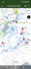
Two trees down that I saw. Apologies for no photos and markings are approximate. One on Leroy is larger of the two and probably needs an 18"er to make it easy to cut. Both are elevated off the ground by a foot or two.

There is definite evidence of trimming on some trails. The less popular (but still good!) trails to the southwest are getting overgrown; blue, parts the white around that area, etc.

1717264069176.png
 

Trail Conditions

Current Conditions

powered by Trailforks.com
Back
Top Bottom