Mercer County Park Conditions

Remediated the downed tree on Red @ East Picnic area... Man it was HOT!! Took 25 minutes and several breaks to get it done.
Checked out the tree on SOB ( pic in above post) and it's hard as nails!.
Will need a power saw for that one.

TAS
 

Attachments

  • DSCN2084.JPG
    DSCN2084.JPG
    196.7 KB · Views: 96
  • DSCN2085.JPG
    DSCN2085.JPG
    188.4 KB · Views: 103
Mercer is in rough shape after last night's storm. Blowdowns all over the place. Sticks everywhere. Windowmakers galore. You name it, we got it. Extra bonus, PSE&G put some fencing up around the powerlines by the West picnic area. Gotta go around. I cleaned up the Christmas tree trail and Yellow Lakeside and it was really slow going. Come out to trail maintenance on Saturday, we need all the help we can get.
IMG_20190723_125336.jpg
IMG_20190723_144524.jpg
IMG_20190723_140732.jpg
IMG_20190723_151223.jpg
 
PSE&G is in the process of replacing the lattice transmission towers with monopole towers. Check out the link here: https://www.psegtransmission.com/reliability-projects/mtb. This explains the recent replacement of electric lines and poles along Hughes and Youngs Rd and also the recent work on the transmission lines at Flock and Edinburgh Rds. I did read somewhere that PSE&G will respect right of way. The alternate 'route' via the West Parking Lot is immediately behind the playground in the vicinity of the picnic tables. Being I was out on Saturday at noontime in the crazy heat not sure whether you can make an immediate left after going under the power lines....I just went down to the cement path and back up to the regular trail. Wish I could be with you on Saturday....I don't know whether you were able to make it out to Van Nest but did a drive by today and did notice that there was some trees down in there from the road.
 
Mercer is in rough shape after last night's storm. Blowdowns all over the place. Sticks everywhere. Windowmakers galore. You name it, we got it. Extra bonus, PSE&G put some fencing up around the powerlines by the West picnic area. Gotta go around. I cleaned up the Christmas tree trail and Yellow Lakeside and it was really slow going. Come out to trail maintenance on Saturday, we need all the help we can get. View attachment 100634View attachment 100635View attachment 100636View attachment 100637
A few coworkers were getting ready to softball at Mercer when the storm hit, apparently it go bad really quick and at least two of their cars were hit with fallen/flying branches. Quakerbridge road had 3 trees down between Hughes and Rt 1
 
Was on 535 next to the park near the CC when it hit, watched a tree blow over...was nuts like driving thru a tornado. Hid in a MCC parking lot away from trees for the few mins it took to blow thru. Just got power back....I suspect there is plenty to do there, will try to get out later this week with the hand saw at least.
 
Al, thanks for the info & pics.. I am heading out there today to do recon for TM and clear & saw whatever I can. I figured it was gonna be bad...
I'll post a report.

TAS
 
OK I am back, had some dinner and took 2 Naproxin... Man I am sore... YIKES! There are trees down everywhere, all sizes.
I started on red from west picnic and headed west. In total I cut and cleared 7 downfalls and removed 1 widow maker. On yellow I made it into Van Nest Up to the big pine trees. Just past that area, another big oak is down. I turned around as it was dinner time.
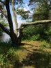
Red along the Lake was clear.
Never got to Orange.
Did not check Paxton Twisty

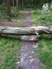
Red trail in the vicinity of the BMX pit is still blocked by two large trees.
Yellow Trail is clear until just past the pine trees.

Thats all I could cover today.

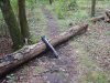
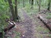
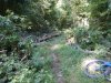
1st two thumbs are from red trail
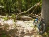
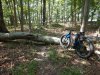
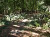
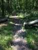
The last two are from yellow where I cleared two pine trees.
Note: I got pine sap all over my gloves & saws... Gotta clean that crap off!

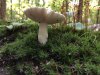
However, I did see a cute Box Turtle crossing the trail!
DSCN2104.JPG


TAS
 

Attachments

  • DSCN2107.JPG
    DSCN2107.JPG
    185.3 KB · Views: 92
  • DSCN2113.JPG
    DSCN2113.JPG
    190.7 KB · Views: 93
  • DSCN2116.JPG
    DSCN2116.JPG
    187.4 KB · Views: 90
  • DSCN2117.JPG
    DSCN2117.JPG
    190.2 KB · Views: 94
I was there today with the best of intentions. Unfortunately I suffered catastrophic failures with both my folding saw and machete. Pics of just a few things I came across below. All were on blue and red by east picnic area

21FAD126-3851-47A0-828D-F682784FA85C.jpeg
7DCAEA90-39F1-41E5-80BC-0605B9D797B8.jpeg


I have a few other photos but for some reason they won’t load.
 
Can you please provide me a location reference? Where on blue is this? Trail looks a bit different with trees across it!

It’s on blue. If you look closely you can see the blue triangle on one of the trees. It’s on the section that runs closer to the lake. As of Saturday afternoon there was probably 6 trees down in the east picnic area, this being the worst. Happy to lend a hand if needed
 
The cleanup continues! Blue is now clear from East Picnic to the Rowing center.
The park ran a brush hog and cleaned blue down to the double bridges!
I cleared this one today.
Plus got pics and locations of additional downed trees.
Here's a beauty just waiting to fall....
Daily nature shot of a nice mushroom.
 

Attachments

  • IMG_0052.JPG
    IMG_0052.JPG
    192.5 KB · Views: 85
  • IMG_0055.JPG
    IMG_0055.JPG
    203.8 KB · Views: 90
  • IMG_0036.JPG
    IMG_0036.JPG
    181.9 KB · Views: 89
  • IMG_0050.JPG
    IMG_0050.JPG
    117.9 KB · Views: 91
A crew of 3 will be out late tomorrow afternoon. Hopefully we can get the remaining sections of blue open :banana:
and the red loop by the river & east picnic.

Have not been over to blue north yet ... almost afraid to go look...
Has anyone been over there and have anything to report?

TAS
 
Dry. Lots of small deadfall, Some downed trees (some possible to circumvent, others not.). Growth along some of the trails, watch for hidden sticks and logs.
387662EA-2CDC-46A6-AFF4-DE7CE25A9D99.jpeg
15373D47-6BF1-441C-98BC-36594C13F548.jpeg
E11DB974-5481-4FCA-9070-133C3A5ED93B.jpeg
387662EA-2CDC-46A6-AFF4-DE7CE25A9D99.jpeg
15373D47-6BF1-441C-98BC-36594C13F548.jpeg
1619A83F-912B-4AA6-9F59-BC284D8C0390.jpeg
 

Trail Conditions

Current Conditions

powered by Trailforks.com
Back
Top Bottom