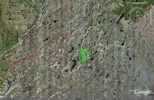
It's on my old hard drive, which has yet to be ripped out of my old, busted computer. If you click on it, you can get a higher resolution version from my flickr account. The green tangle of trails are all from Mahlon to Berkshire Valley Rd, and the white lines connect that to Minisink Park, Stephens, Deer Park Allamuchy, Kittatiny, Waywayanda, and Farny State Park, with a bunch of WMA's in between. It mostly just crosses roads, but occasionally travels down them for a couple of miles. The red lines are the Paulinskill, Sussex Branch and Lackawana Cutoff, which make a nice @80 mile loop out to PA.
Clicking on the higher res image, and spending some time in google earth looking at terrain features(their photos have changed) should allow you to figure out where most of those trails are, but there about 5,000 wrong turns you could make. Luckily it's New Jersey, and a wrong turn would see you lost in the wilderness or falling into a crevasse or anything.