The Hurricane Ida Chimney Rock Relief Effort Thread

It is on the watchung ridge that is exposed to the raritan river basin or is it the newark basin?
General Washington used it to spot troops coming up from Philly (or trenton, or wherever)
so it is very "exposed"

For the last 35 years i've been around it, that ridge takes a beating any time there is a weather event which lines up with the valley.

I'd start thinking about removing all the dead stuff from underneath - they do prescribed burns, but there seems to be more fuel now.

What do you do with all that stuff I feel like fire is the only efficient way to remove that stuff. Also it isn't the fuel on the ground that is blocking trails, from the pictures it looks like healthy trees are what keep toppling over, maybe there should be human intervention on what tree it to succeed in the void left by the old tree.

Talking out my ass here

In California they pile it up next to the road, and take it away.
The strategy helped save South Lk Tahoe.

Tree is gunna tree ?
 
I think it is just the nature of things unfortunately.

It's a tough environment for trees because of the specific geology of the area, which has been revealed in unprecedented detail since the storm. Roots have to go wide, they cannot go deep because of the presence of solid rock. Add to that the water, which as we know tends to roll down hill, washing out the root systems and leaving the trees vulnerable to winds.

This particular storm was really all about the water. I mean, the damn dam overflowed! Entirely new streams appeared overnight, and small ones turned into massive gorges, with beds of solid rock you can drive an ATV through. I've been watching these trails for decades, and Ida caused easily a century of erosion in one night.

I try to imagine what it looked like at peak - it would have been really something to witness it.
 
Water made The Grand Canyon.

There's no preventive maintenance that will stop water over time. We do what we can with what we have. But tornados, hurricanes, fire, and the like are always going to win.

Water no but those trees? Maybe I'm spoiled up north
 
Scouted some of yellow this morning. Started by the Train Simulator.

Just a bigger pile of rocks/dirt right before the bridge crossing:
20210910_101900.jpg


Other side. Wooden bridge has been swept a few feet to the left. On the right side (not pictured) water is starting to collect:
20210910_122137.jpg


Wooden bridge has been buried...
20210910_122301.jpg


Rock pile formation on Train Simulator:
20210910_102241.jpg


Before image. This is on the way back to Miller Lane after High Tech climb:
20210910_112159.jpg


After image. I did what I could with my hand saw to make clearance for anyone who wants to chain saw it:
20210910_115205.jpg


Afterwards, I just cut across onto one of the connector trails then headed back down. Everything was fine there. Didn't get the chance to check out the other connector trail and the beginning of the down hill part before you hit the intersection. Good running into @Patrick and @jklett repairing the wooden bridge by ballfields.
 
Friday, September 10th

First day of formal park recovery today. We're still working out the limits we need to work within, so this was not an official TM open to the public. We had 5 guys from High Tech plus a handful of known regulars to start. First focus was on the ballfield trails for reasons that are not especially important right now. It was just a starting point.

The bridge from the fields to the start of the middle run down to the concrete bridge has been secured:

ngbPgOr.jpg


There was a lot of damage between the concrete bridge and the big wooden bridge. After some deliberation on this, the trail now routes towards the hill, and a new bench cut was put in to make this ride better. This was on the radar before the storm so this was a good opportunity to make this section better. IMO this is a WIP and will need some tweaking as it gets ridden in.

vtVFguF.jpg


Trail was rerouted a bit before the concrete bridge as well. Maybe more to come on that.

The big wooden bridge also fixed.

llfLJuZ.jpg


The transition off this bridge has also been made friendlier.

wuKtEu3.jpg


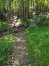
Taking a left here there is a long straight gravel section. This was where a small gulley had formed from the storm. No more:

Q7BIV7x.jpg


At the end of this straight is the sharp right turn to get into the woods. This has been an issue for a while. It's been filled in. Hopefully it stays longer than the last time I did it.

UF6lbx9.jpg


Some of the water-bar-like drop-offs that had formed in the trail were smoothed out.

o5BH7f5.jpg


The log pile has been fixed on both sides.

lfZhmUo.jpg


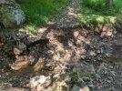
The fall line erosion that has been getting worse & worse in the last year went out of control in the storm.

Before:

aoWxfTV.jpg


After:

P5v8lwp.jpg


The gorge was starting to erode into the hole. We built it back up with a rock base and topped with dirt.

YEtTCVu.jpg


The reason you see a pile of dirt there is because we all ran away when the yellow-jackets went nuts. I got hit 3 times today.

The trail to the gorge has been beefed up and properly re-routed:

5jXm8RP.jpg


There's more but that's enough for now with the pictures.

The low point before the water crossing to Gilbridge is a cesspool. Literally a cesspool. The sewage overflow seems to still be overflowing, and it's greasy poop. I mean, it's literally poop. It's greasy and smells awful. It has not dried out in the 48 hours since I was last there so it seems like it's still overflowing.

We scouted the black trails while the High Tech guys ate lunch. Black are the trails right off the Gilbride parking lot. For the most part they are ok. We were surprised but they handled the storm ok. Kirt and I talked about it, and maybe we do a few hours over there towards the end but it's not worth focusing on right now.

After that we scouted yellow then went over to blue to help fix a bridge.
 
Middlebrook trail on blue. As you can see, the bridge was a bit misplaced:

HPuYyfP.jpg


Pieces were put back into place and the transition was worked on:

D3s3QZr.jpg


Slight problem...the stream is wider than it used to be:

hV533Ph.jpg


Some work will need to be done to ahhh...bridge...that gap. Stay tuned, it'll get closed.

We also cleaned up some of the rubble off to the left of the picture above. Somehow it ended up piled up perfectly in front of this log. Not sure how this happened.

DvP7Fs7.jpg
 
IMO this is a WIP and will need some tweaking as it gets ridden in

Thank you Norm, and High Tech and the others that worked on this!

Is it OK to ride on any areas of CR while this work is being done or better to just stay away until it’s done?

I know not everyone looks here and people will ride regardless, it’s the old “is Six Mile rideable” dilemma, but I’ll do my part and stay away if the powers that be say so..
 
Cleared lower High Tech, the trail to Miller Lane, then cleared down the Yellow Climb to the rubble pile. I think that whole side is rideable now except for the rubble pile, which is rideable. I didn't check the newest trail along the river to the damn dam.

20210910_083723.jpg


20210910_082608.jpg


20210910_081013.jpg


20210910_090233.jpg
 
Is it OK to ride on any areas of CR while this work is being done or better to just stay away until it’s done?

I mean, you can. I am not sure how fun it's going to be. You could start at the ball fields, ride white, then ball field trails, then black in theory. There are a few issues with that - first is the sewage at the low crossing heading to Gilbride. That's gross and probably not fun.

Second problem is that Gilbride is taped off so the county doesn't want anyone there yet. Black also has a tree down as well as the gulley is bordering on dangerous.

Yellow is sort of hit or miss depending on your skill level. I scouted lower yellow today and it's rough in 1 spot which won't take too much work. The fire road climb to the hawk watch, I am told this is real washed out, which I could understand.

Orange is unknown - the guardrail climb/descent is bad. I would avoid that for now.

Red & blue are unknowns to me.
 
Thank you Norm, and High Tech and the others that worked on this!

By the way, I would be remiss if I didn’t say thanks to Kirt for leading the charge here. He’s the jorba rep for both parks and deals with the paperwork and park communications. I show up to help work & socialize what we’re doing. But none of this happens without him.

Obviously also many much thanks to Paul and the High Tech crew.
 
Red and blue are my daily bread, I've been riding them every day since the storm and trying to improve what I can when I have the opportunity.

Red is mostly rideable except for the stream crossing at the top which has turned into a gorge. The same stream crossing in the middle section is also a bit precarious. The middle section also has caution tape deployed the purpose of which I cannot detect.

Blue is mostly rideable except for a similar gorge at the top stream crossing near the Old Tullo connector. The bottom section has some trees that haven't been cleared yet.

White is mostly rideable as well with just one fallen tree remaining and the infernal mud on the reservoir-adjacent sections largely washed away by the rain. That stuff was nasty, you couldn't even walk through it easily.
 
Walked White, Orange, Red and White today. Great cleanup on ballfield part and White. Outer Red does now have its own Grand Canyon near the top, probably only fix is a bridge. That was always a fun crossing. Guardrail bottom climb is a ravine, think all it would take is rake and tamp the rocks back in place. Wouldn't be easy to skirt around either side of ravine when climbing.
 

Attachments

  • PXL_20210911_151533179.jpg
    PXL_20210911_151533179.jpg
    211.6 KB · Views: 136
  • PXL_20210911_151344588.jpg
    PXL_20210911_151344588.jpg
    195.3 KB · Views: 135
Walked Yellow (and Pink and Green, too) this morning. Did not cover IMBA and Voseller, Diagonal or Granola, or the two sections adjacent to Gilbride. The trees near Miller Rd. that Kevin posted are cut already (thanks). There is a tree (see @Cafe Dave post #41 below for picture and map) encased in a bundle of vines located when you are riding IMBA/Voseller counterclockwise, then at the top, where the trail turns west, take the first right and ascend to about 40 yards short of the crest south of Miller Lane. Some of the vines looked to be poison ivy, so I passed.

Got rid of about 188 rocks on Train Simulator, most from the big washout toward the north end. The washout could probably use work, as a lower priority. The fireroad up to the Hawk Watch and Kram's is fine up to the parking lot.
 
Last edited:
Yup, just want to extend my gratitude as well to the trail maintenance crew. Awesome job with bringing these trails back to life. Hit everything but yellow and it was all rideable except for that gully at top of blue and the rutted part of the guardrail climb on orange as others have noted. Improvements on black are awesome! Love bench cut trails. Bridge behind the ballfields is also looking spiffy!

Here is that gap in blue with my Vitus for scale.

20210911_171723.jpg

20210911_171518.jpg


Here is a view looking uphill on orange near the guardrail.

20210911_195737.jpg


But on the brightside, i noticed that blue was surprisingly dry. Here is a view of the worse of lower blue. Can be easily skirted while still staying within the boundaries of the trail.

20210911_165619.jpg


20210911_165622.jpg


And i saw the gravelly shoulder near the trailhead of red on Chimney Rock road has been paved. Sweet. Perfect for safely scrubbing off speed before the hard right through the chain link fence after sprinting across the road from the guardrail on orange.

20210911_182126.jpg
20210911_182129.jpg
 

Trail Conditions

Current Conditions

powered by Trailforks.com
Back
Top Bottom