


You are using an out of date browser. It may not display this or other websites correctly.
You should upgrade or use an alternative browser.
You should upgrade or use an alternative browser.
Stephens State Park Conditions
- Thread starter pedals
- Start date
A few more down today:
1st two on XY trail
View attachment 245509View attachment 245510View attachment 245511View attachment 245508
Orange towards ranger station:
View attachment 245512
View attachment 245513
One more in this area (at the turn, been leaning over for years and finally fell). No picture of the tree:
View attachment 245514
Thanks for the intel!
If you could use Trailforks, strava maps are super difficult for me to decipher. No trail names and zoomed in makes things a bit tough.
Teutonic
Well-Known Member
I was always using TF until now recently it wasn't working well (free version).Thanks for the intel!
If you could use Trailforks, strava maps are super difficult for me to decipher. No trail names and zoomed in makes things a bit tough.
In the XY trail you should notice Hally, and it is right past Golden intersection.
Orange is the steep decent down to the broken gravel road to the ranger station at the Main Park entrance.
The other one is on red/white headed from ranger station towards "3 tier".
I'll give TF another try.
I was always using TF until now recently it wasn't working well (free version).
In the XY trail you should notice Hally, and it is right past Golden intersection.
Orange is the steep decent down to the broken gravel road to the ranger station at the Main Park entrance.
The other one is on red/white headed from ranger station towards "3 tier".
I'll give TF another try.
Have the local TF admin person make you a reporter.
Teutonic
Well-Known Member
Chainsawer and I were discussing how best to do this. He likes a printout with dots of all the trees down, but also likes to see the size of the tree at each location. Can this be done via TF?Have the local TF admin person make you a reporter.
Chainsawer and I were discussing how best to do this. He likes a printout with dots of all the trees down, but also likes to see the size of the tree at each location. Can this be done via TF?
taking a pic and uploading it as a report on TF puts it all together. The photo has the location embedded, so it goes directly onto a zoomable map. There is also a description section.
Then when it is remediated, you can report time directly on that report, and give it the all-clear.
Planning on doing brush back work on the Tilcon Lake Trail next Saturday (8/24/24) if anyone is around to come with. If there's enough of us we can split up and do the Mazes instead, they're not as bad but still plenty of arm scratchers.
mtn
Well-Known Member
Due to lack of feedback and preparation, I didn’t do much today. Someone did some cutting of smaller trees. I made the one on pink rideable, but the logs may want to be cut back. And there are a couple clumps on white near the hally toe or whatever. The new clump has had most of the smaller (under 12”) stuff cut, just not moved. And had I not forgotten that my gas saw was on my garage floor, I would’ve cut the larger remaining one. You can still get by underneath it.Any recommendations on a clump of trees to hit that is easily accessible? Will be passing through and will get some today. Not biking in.
The second clump is closer to hally toe and I only cut one out there. Looks like it has been down a while and really isn’t rideable. If anyone feels uncomfortable cutting that, let me know and I’ll make note to cut it whenever I’m back that way. It’s still cutting at chest or shoulder height, regardless of where you cut the tree and therefore a bit unsafe.
mtn
Well-Known Member
You all will have to manhandle a couple logs out of the way. I’m not doing that by myself. The dangerous log under on white has been cleared. That was some extremely bad tension and compression and after a few pinched chains, two tanks of fuel, and two chainsaws (ran out of fuel and switched to battery), it was down and somewhat cut.
I talked to the park maintenance crew who were driving back there. Supposedly cutting that lake trail. This was Thursday. NJPM vs VolTM can vastly differ as you knowPlanning on doing brush back work on the Tilcon Lake Trail next Saturday (8/24/24) if anyone is around to come with. If there's enough of us we can split up and do the Mazes instead, they're not as bad but still plenty of arm scratchers.
Red Mosquito
Formerly RLB the Scrapple Boy
taking a pic and uploading it as a report on TF puts it all together. The photo has the location embedded, so it goes directly onto a zoomable map. There is also a description section.
Then when it is remediated, you can report time directly on that report, and give it the all-clear.
Is this available to everyone? Or just users that are enabled as reporters by the admin?
Is this available to everyone? Or just users that are enabled as reporters by the admin?
I think so!
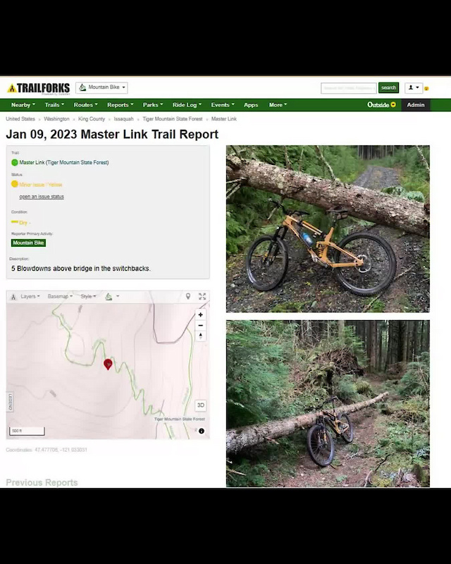
How To Submit A Trail Report And A Trail Work Report With The Trailforks App Video - Pinkbike
This short video clip demonstrates how to submit a geo-tagged trail report, and a trail work report, with the Trailforks App when you are out on the trails.
Red Mosquito
Formerly RLB the Scrapple Boy
Nevermind I see it now. It's hidden in a non-obvious spot (under the record button). I never record rides with the TF app so I wouldn't have found this without really tryingIs this available to everyone? Or just users that are enabled as reporters by the admin?
I talked to the park maintenance crew who were driving back there. Supposedly cutting that lake trail. This was Thursday. NJPM vs VolTM can vastly differ as you know
Excellent. That was going to be a doozy of a job...maze needs some still but it's way more manageable.
I rode around the lake around 10am yesterday. It was still hard to get through due to overgrowth.I talked to the park maintenance crew who were driving back there. Supposedly cutting that lake trail. This was Thursday. NJPM vs VolTM can vastly differ as you know
Thanks for the Intel, just as I figured and why I said NJPM vs VolTM.I rode around the lake around 10am yesterday. It was still hard to get through due to overgrowth.
What do these abbreviations stand for?NJPM vs VolTM.
mtn
Well-Known Member
new jersey park maintenanceWhat do these abbreviations stand for?
volunteer trail maintenance