Rode "stone gate" for the first time

Stocky

Member
We usually do our 6am Sunday Mahlon ride ( been at it not for 3 months) .At the last minute my buddy called Friday and said he's on his was home ( it was 3:30) "Ya wanna ride ?" he asked . Hell yea. I close my shop at 3:30 on Fridays . We also rode Sunday morning.
Some how we've been bypassing Stone Gate every time we ride Mahlon, just never noticed the left turn before Devils Satircase.
HOLY CRAP, what a great friggin trail. It's by far the best trail Mahlon has to offer ( unless of course I'm missing something else) .
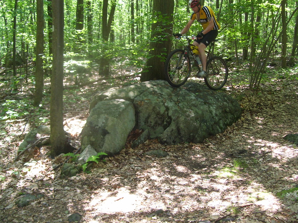
Fast single track, lots of trees to cross, rocks to climb, that rock ledge, the climb up to the rock platform just before what I assume is " Stone Gate" .

Did the Stone Gate trail always exist or was it done to bypass the Staircase ? Just curious.

Also somehow I didn't notice the "Turtle" it's on this trail correct ?

Can you guys give us rookies some thoughts on riding up and over those few LARGE rocks right in the middle of the trail . What's the approach tecnique ?

The same goes for when you approach those pyramid log formations. What's the proper way to get over them ?

Also hats off to the two guys that we passed just as we hit the bottom of Stone Gate / Devils Staircase. They were riding up the Staircase and then headed up Stone Gate.
 

Fogerson

Former Resident Nerd
Stone Gate is a fine trail. Cascade Trail (that overlooks the high school) is also a nice run.

Dunno' why Stone Gate was constructed...I do know I'm glad it is there because the Devil's Staircase and I have no love lost for each other.

The Turtle is not on that trail. It is north of the picnic area on the other side of Weldon Road. I keep meaning to mark it on my GPS every time I ride by it so I can show y'all where it is, but I keep forgetting. I've attached a KMZ from a little ride that I know goes by it. I've put a place mark about where I think it is. At any rate, if you ride this route starting at the picnic area, you'll ride by the Turtle within a mile. It'll be on the right hand side of the trail.

If we're thinking about the same rocks on Stone Gate (e.g. one that pops you up on to a rock ridge with a *hard* left hander near the end of it), the key is momentum (not a lot). If you mosey up to them and pop your nose up, you're probably not going to grab enough grip to carry yourself up. I did this my first few times, got my front tire up the rock, but just spun (and stopped).

If you carry a little bit of speed (again, not much is required), popping your front wheel on the rock and some pedaling as your rear tire touches the face, will get you up it.

The pyramid logs are easy. Just ride over them like there were dirt bumps in the trail. Just make sure your weight is back a bit after your front wheel clears the peak and make sure you have either enough momentum to carry yourself over, or be ready to give the pedals a push to make sure you don't come to a screetching halt when your rear tire hits the ramp up.

Tim Fogerson giving technical riding advice. This is scary :scared:
 

Attachments

  • turtleApprox.kmz
    4.1 KB · Views: 72

Stocky

Member
Fogerson, thanks for the suggestions.

I could not open the file, not sure why not.

Our usual route is park at the main lot, cross Weldon road and head up the RR bed or I guess some call it a fire road ?
We make a right about a mile up and "head in" a short ways up we cross that 2x6 board and continue onward until we get to a "T" in the trail left is down the hill and right is up the steep hill to the highest point in Morris County, that's the way we go most of the time.
Get to the highest point and fly down the backside on those gravel switchbacks.
I think we come to another T in the trail, we go left , there's a sign for the picnic area, we take the trail to the left and it eventually takes you out to the picinic area/camp grounds. We make a right and head out to Weldon Road.
We make a left and head down Weldon and jump back in at the Headly Overlook.
We do the "Wall" and then to the Staircase , now of course we will bypass the Staircase until further notice.

So were in relation to our route could we hit the turtle ?

All of my riding should improve once I stop riding my Trek 4300 and replace it with a Gary Fisher Hi-Fi deluxe.
I'm going 29 !!!!!
 

Fogerson

Former Resident Nerd
The file is a google earth file; if you don't have that on your computer, you won't be able to open it. I've attached a picture...

I can't picture your route exactly, but when you're near the sign to the picnic area, you are close.

Basically, from the picnic area, you take a left shortly after getting on dirt. After that, keep to the right until there is a trail that heads off sharply to the left. The turtle isn't much farther.
 

Attachments

  • turtleapprox.jpg
    turtleapprox.jpg
    85.2 KB · Views: 100

Stocky

Member
You also need to add Cascade to your loop.

Ok Norm, Point me in the right direction.
We've been looking for ways to increase the lenght of our ride. It usually clocks in at about 9 miles.

Cascade sounds like a ski trail, is it in that direction , towards the Snow Bowl ?
 

Norm

Mayor McCheese
Team MTBNJ Halter's
After you take the right off the RR bed, keep taking rights. Don't go up to the highest point. Then when you get to the fence, go up and over the hill, take another right or 2, then go down the hill and take a left on that old jeep road.

As for describing how to get to Cascade from there, forget it. I've done it 6 times now and every time I screw up one of those camp road turns, this past Saturday included. Bunch of rights and lefts to get there.
 

Stocky

Member
When we come in to the Overlook from the road, you can head left up to the Overlook or down to the right, both dump you out to that grassy knoll at the beginning of The Wall .

Is that Cascade , the left up to the Overlook ?

We've done that many times before, another favorite, we skip it sometimes if we are short on time.
 

Stocky

Member
I just looked at the map again, The Overlook I'm talking about is nowhere near the Overlook that looks towards the HighSchool.

My buddies and I have some recon to do !
 

Fogerson

Former Resident Nerd
When we come in to the Overlook from the road, you can head left up to the Overlook or down to the right, both dump you out to that grassy knoll at the beginning of The Wall .

Is that Cascade , the left up to the Overlook ?

We've done that many times before, another favorite, we skip it sometimes if we are short on time.

You're talking about Headley Overlook. In the context of Cascade, we're talking about overlooking the highschool. Cascade is on the north side of Weldon, not the south side like Headly Overlook.

Cascade trial is marked with that name on the map.
 

Shaggz

A strong 7
Let me know if you want to do an after work ride. It may be an abbreviated tour, but I can help you piece it together. Between the Stephen's ride this coming Sunday (try to make that), my son's birthday party and vacation, the next three weekends (really, Sundays for you) are no good for me.
 

Stocky

Member
Let me know if you want to do an after work ride. It may be an abbreviated tour, but I can help you piece it together. Between the Stephen's ride this coming Sunday (try to make that), my son's birthday party and vacation, the next three weekends (really, Sundays for you) are no good for me.

Thanks for the offer, not sure you could tolerate our many catch your breath breaks.
Where is Stephens and what's the ability level ?
 

Fogerson

Former Resident Nerd
Okay boys, stop your posturing ;)

If I can go for a ride with Sean (anrothar) at MD, Stocky can ride with Shaggz. There is no way there is a bigger fitness gap between you and Steve than there is between me and Sean. It just isn't possible.
 
J

jimex7

Guest
If you want to hit MD this weekend maybe sunday early let me know nice slow paced ride.
 

rayder

Active Member
what is the turtle

is it a trail formation which resembles a turtle, a catatonic turtle that doesn't move or a dead turtle, or maybe one with an incredibly small range.
 
Top Bottom