Berkshire Valley WMA?

[here was our ride.
http://connect.garmin.com/activity/18837170[/QUOTE]

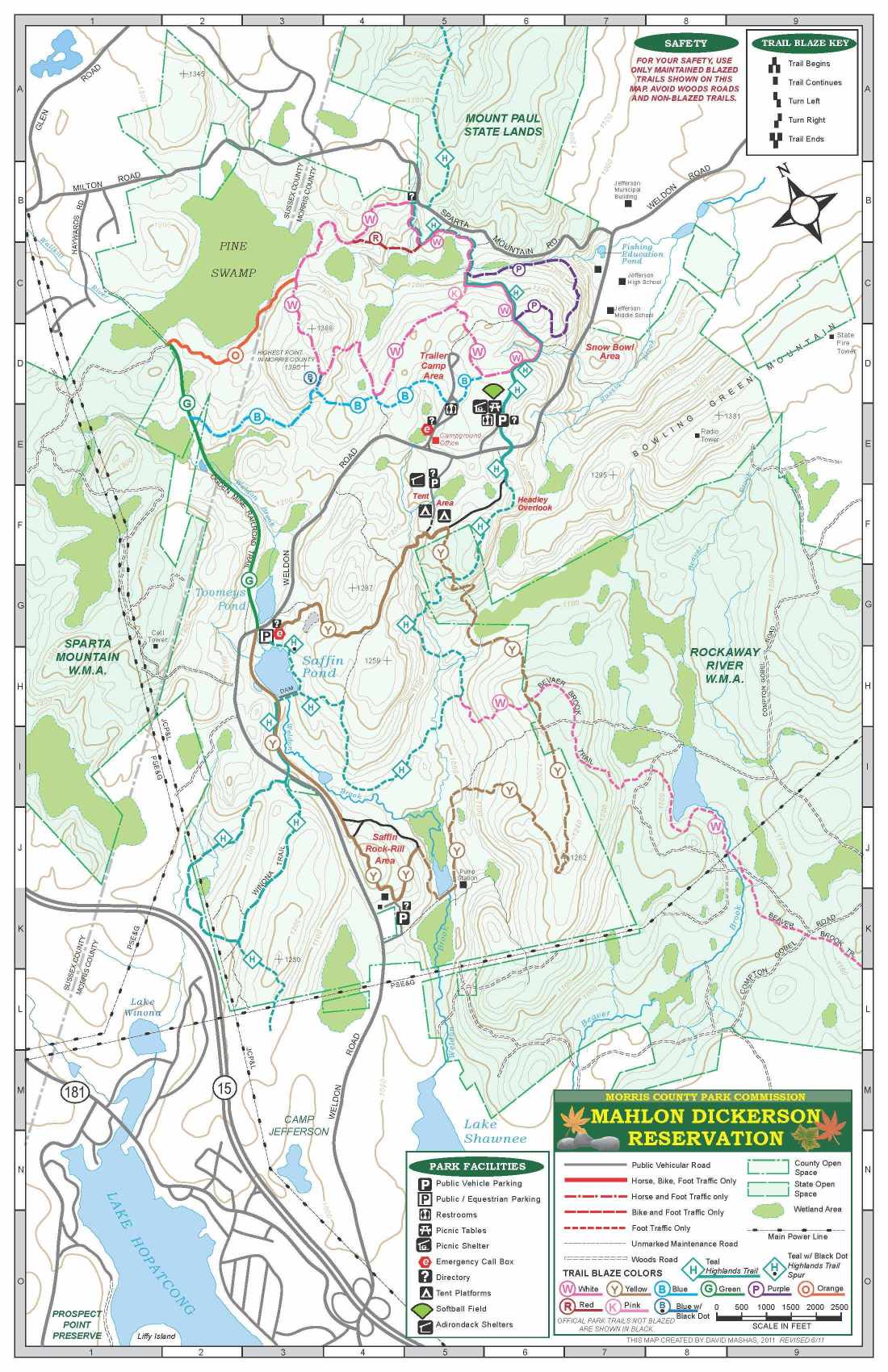
With exception of going through the Boy Scout camp, that looks like a good route. Staying on the ridge above Green Pond should not be a problem, just don't plan to park anywhere in the community, security will hastle you. I would also not recommend going near the fence for P.A. and instead would take the ealier route down to the pipeline. I think that is what you took. Crazy steep with rock ledges and drop offs. We took a F150 down that once.
 
Yes. Very steep.

How do we do that loop and skip the boy scout camp?

When you come out on Durham, make a left, then right onto Timberbrook. Keep left to stay on Timberbrook and farther up you can pick up the other trails.
 
If you could figure out a way to connect the Water Tower to the trails at the north end of the new development there, that would kick ass. It's one of the only real stumbling blocks on the connector.

Well I decided to have some fun on my lunch hour today and do some exploring. There is a trail that starts at the water tower and that will take you across the new development and eventually drop you on to shippenport road. I tried looking around to see if there was another was out of the bottom of williams rd, but its pretty grown in. I could not find a way out other than up the hill towards the water tower. But to connect now, you could just come out of the berkshire wma, ride across howard blvd, up to the water tower and back onto the trail. My GPS broke as i mentioned, but I sketched my route today as best I could in google earth
 

Attachments

  • Water tower.jpg
    Water tower.jpg
    336 KB · Views: 280
I've taken the route you just posted before, but I like including bars on my loops. The way I had been going, was to head downhill and to the left from the water tower, cross the little creek near the end of williams, ride up the bouldery washed out trail, which put me behind the houses on that cul de sac in the new development. You've got to bushwhack for a few hundred yards before you reconnect to the original trail. Then it's(was) across a cleared but unconstructed lot, and pretty much straight across to connect to the trails running into the back of pub 199. I suppose that little section of trail isn't really worth the effort, and I could just come out where you did(retaining wall), hang a left and ride up to the entrance to the trails on the north side of the development....
 
Wait, no, I misread your map. I have taken the route you took, but my prefered route is the complete opposite direction. the other new development. 😀
 
ya it kinda of a mess now in the area behind the pub now. I rode to the little river bed, but it was bushwack city, so I turned back.

There were a bunch of trails in there. I only took one route to shippenport. But there was another that would have dropped me near lake rogerine. It was kinda like a trip back in time. I lived on Arnold rd when I was a kid (street above williams) so we used to walk around/dirt bike back there all the time. I think that was my first time on those trails in probably 25 years.
 
Did you know that it would technically be illegal for someone to regularly (once every couple of days or so)walk something like the route I've highlighted below, which would connect two trails cut off by the development, through the woods, till it was well tramped in? Illegal and against the rules. Just thought I would mention that. :hmmm:
 

Attachments

  • illegal.jpg
    illegal.jpg
    313.7 KB · Views: 283
Tried some of the WMA north of route 15 today:
http://connect.garmin.com/activity/19682851

For Sean:

* We ran into a guy with a gun who said we were on Jefferson gun club land. This was after you seem to have gone down to that road where we saw him, turned around, then trailblazed on top of the ridge. Did you, in fact, trail blaze?

* There was a very wet spot about 30 minutes or less into the ride. Looks like the road was eaten by a beaver dam. When you went it was likely frozen over. Is there a better way around?

* Is the southern point on that loop anything that will reasonably be able to connect up to the crossing of route 15?
 
We ran into a guy with a gun who said we were on Jefferson gun club land. This was after you seem to have gone down to that road where we saw him, turned around, then trailblazed on top of the ridge. Did you, in fact, trail blaze?

That must be Hercules Trap & Skeet Club (187 Weldon Rd.). I didn't even know it was there.
 
Tried some of the WMA north of route 15 today:
http://connect.garmin.com/activity/19682851

For Sean:

* We ran into a guy with a gun who said we were on Jefferson gun club land. This was after you seem to have gone down to that road where we saw him, turned around, then trailblazed on top of the ridge. Did you, in fact, trail blaze?

* There was a very wet spot about 30 minutes or less into the ride. Looks like the road was eaten by a beaver dam. When you went it was likely frozen over. Is there a better way around?

* Is the southern point on that loop anything that will reasonably be able to connect up to the crossing of route 15?

I should have gone with you guys, I know a couple of guys in that gun club that I could have name dropped. Did he make you turn around?
 
That must be Hercules Trap & Skeet Club (187 Weldon Rd.). I didn't even know it was there.

Based on where we were and where that address is, I think this was a different one. If you look on the map:
http://maps.google.com/maps?q=197+w....970761,-74.577942&spn=0.033894,0.073128&z=14

It was the south extension of Compton-Gobel Road. Maybe it's the same but this guy said something like "Jefferson gun club" or something. He used Jefferson as part of the title.

It's not too far from this 713 Tract:
http://maps.google.com/maps/place?o...+Tract&hnear=713+Tract&cid=384472696574754614

What on earth is 713 Tract?

Compton-Gobel Road makes Weird NJ?
http://theweirdusmessageboard.yuku.com/reply/23523/t/Re-Weird-Roads-of-NJ.html

I should have gone with you guys, I know a couple of guys in that gun club that I could have name dropped. Did he make you turn around?

He did. We would have just looped back around to where we ended up anyway. There was also another road that was diverging from the track that looks to have been headed straight for that 713 Tract. Next time I would check that out to see where that leads. I would also try and find a better crossing for that mess the beavers made. That's actually just before we jumped onto Waldon (not Weldon) Road on Google Maps.

This is where the gun club was:
http://maps.google.com/maps?q=197+w...223,-74.583285&spn=0.004237,0.009141&t=h&z=17
 
I made a polygon kml file out of the Rickaway River WMA and threw it on the MD Google map for now:
http://www.mtbnj.com/wiki/Mahlon_Dickerson#Google_Map

Just to give an idea where it sits in the MD scheme of things.

Looking more at Google Maps it seems like that road continues to run along the top of the ridge alongside Picatinny Arsenal. Anyone ever try that out?
 
That reminds me, Tommy from MCPC was going to send me the GPS coordinates of MDR borders...I have his info, I should get that...

I did find it interesting that the WMA reaches well into what I would have considered "MD proper". How much you want to bet the MD coordinates and the WMA map don't actually agree?

On a side note I think the MTBNJ Mapping Project is about to set sail.
 
I did find it interesting that the WMA reaches well into what I would have considered "MD proper". How much you want to bet the MD coordinates and the WMA map don't actually agree?

On a side note I think the MTBNJ Mapping Project is about to set sail.

If you look at the published MDR map, you'll see that part of Stone Gate and (all of) The Wall are not in MDR proper according to the map. In fact, when Tommy, Steve, and I were walking SG earlier in the month, we noticed this could be the case based on some of the signs (e.g. fish & wildlife, etc.) posted and that is when the whole GPS coordinates of surveyed borders came up.

Funny you should mention a mapping project as it is my intent to turn off smart recording on my Garmin and collect high as much detailed data as I can to build an accurate trail map. Don't be surprised if it ends up being semi-official as Tommy was pretty excited that I already had a bunch of gps info on the trails up there.

On a side note, I've been dickin' around with the Blackberry development environment and think I could put together an app using it's GPS that could make such things a little easier...
 
Back
Top Bottom