Hi, this is a strange question…directed at those who are familiar with Stephens near Station Road. I have a friend who owns a house backing up to near Stephens, west of station road.
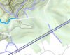
Somebody owns a “landlocked” parcel of land butting up against Stephens. It’s currently all nice woods. The guy wants to build a house on the land, but needs a driveway to access the land. He’s proposing building a narrow driveway on a “two track” road from Cheri road back into his landlocked land.
My friend has several old surveys showing that this Two Track was actually a road once upon a time. If it’s an old road then the guy would have no right to turn it into a driveway and couldn’t build back there. Several old surveys support the old road idea.
The guy who wants to build has several other old surveys that do not show an old road.
I’m looking for further evidence that there must have been an old road. I know that at the White Trail, right where it intersects with blue trail (on the eastern side) there’s an old standing chimney and house foundation. There appears to also be a stone wall heading east for at least 1/6 of mile from that house foundation.
I think it’s common sense that if there’s an old house out there, there must have been a road to access that house, and this would support the road idea in court.
My question is, is there anything else out in those woods that you’re aware of that supports a road needing to be there to have the stuff built? For example, I’ve heard there’s some sort of “old monuments” out there too, but don’t know where they are.
If you’re aware of something, would you please let me know and perhaps describe how to get there?
Thanks for any help,
Eric