Need Info on Hershey/Harrisburg PA Trails

MST.ESQ

New Member
Anyone have info? I may have a few hours this Friday morning before I need to be at a meeting. Unfortunately, Hershey is over two hours from Raystown Lake. I need something within 30 minute drive of the Hershey Hotel.

I found very limited info on the following:

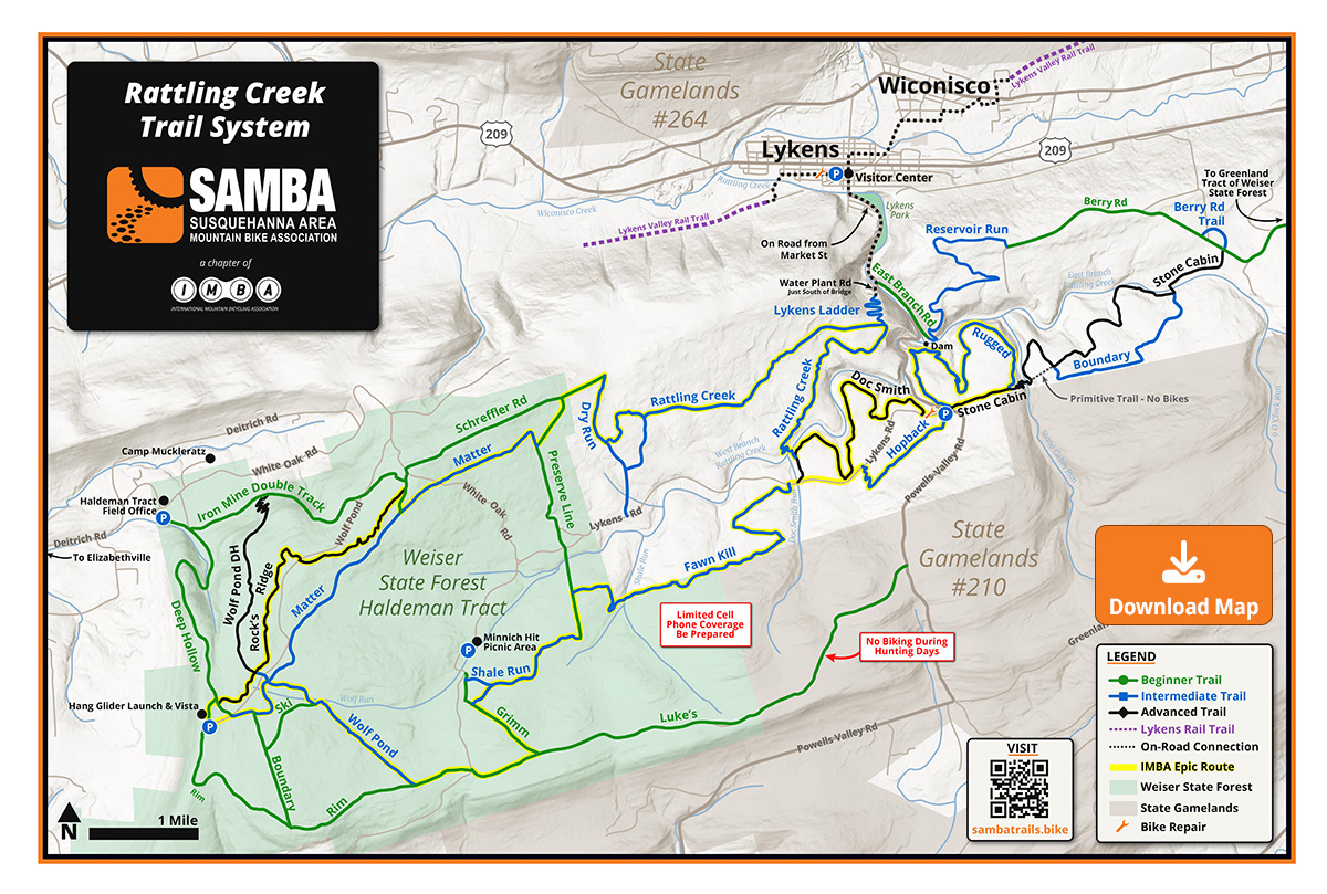
Swatara State Park (7 mi of trail?)

Mt. Gretna (3 miles from Hershey - Mt. Dick trails best in area?)

Team Harrisburg's Race for Chocolate Course - 5mile loop in Hershey?

Lamb's Gap (10.5 mi loop just north of Harrisburg - may be closed by PA Game Commission - see MTBR trail review http://trails.mtbr.com/cat/united-states-trails/trails-pennsylvania/trail/PRD_170012_4573crx.aspx)?

Any suggestions?
 
I think your best bet will be at Mt. Gretna. Up the hill/mountain there are trails on both sides of Pinch Rd. Gov. Dick is probably the better bet because they cut down alot of trees last year on the mt. across the road in an attempt to erradicate the gypsy moths, and I don't know how that affected those trails. Check out http://www.sambabiker.com. They're the bike group involved in that area and have trail and map info. for Gov. Dick on their site.

I think Lambs Gap, and most PA Game Commission land, is restricted for bikes, so don't count on that.

(I'm a Central PA native and try to keep up on mtb trails there for the times I go back to visit family.)
 
Last edited:
Thanks guys. Looks like I'm going to stop at Mt. Gretna. Too bad I don't have time to drive further out as I have been dying to get out to Raystown Lake.
 
Somewhat small but fun place indeed if you are ever in the Hershey area (About 20 minutes from both Hershey and Strasburg). There is one large loop that is something between wide single track and double track, but more fun than a fireroad. Very well marked trails are easy to follow when using the sambabiker.com map. I followed the recommendations to take trail #4 from the top of the hill - one rock/boulder strewn downhill with flow that could be cleared with a hardtail. Very fun.

I will post pictures tomorrow of the logging that is going on as a result of a gypsy moth invasion. Whole sections of the game lands across the street and a small part of Gov. Dick park were cleared due to moths from what I was told. I was more disappointed to see that someone went around the park marking up trail user signs to highlight the words "no tree cutting". It is one thing to speak up against the clear cut operation - but another to engage in your own form of vandalism to get your point across. I'm sorry, but I am not sympathetic to your message! It was sort of a buzz kill on an otherwise fun morning.
 
Pictures of Mt. Gretna

Picture from car is of logging across the street in the State Gamelands. The trail picture is of the large outer park loop.
 

Attachments

  • IMG00032-20100416-1347 (2).jpg
    IMG00032-20100416-1347 (2).jpg
    349.2 KB · Views: 210
  • IMG00034-20100416-1516.jpg
    IMG00034-20100416-1516.jpg
    260.9 KB · Views: 195
Thanks for the ride report and the pics. The logging gives this place an odd look. It's too bad about the vandalism. It's unfortunate when people spend the $ and time placing signage and other trail features just to have it wrecked.

My sister- and brother-in-law have a house down in the village below these trails. For some reason, on the occassions I visit with them there, I don't have my bike. I'm going to have to make a serious effort to change that.
 
Going to Hershey Park this wknd with the family. Noticed a trail system on trailforks right in Hershey, 9 min from hotel. Anyone been??
 
A few years ago I hit these on my way to Raystown. I’d compare to Chimney Rock/Nassau.
Was going to do the same once but it rained as we drove through so never stopped.
Please provide Intel for those who want to know.. like me lol. Thanks
 
I have relatives that live in Hershey, I ride the trails by the Med Center when I visit. Definitely worth checking out before you stand in line at the park all day. There are trail maps and pretty easy to navigate.
 
Is rattilig the same as roaring Creek.
@Fat Trout did we ride roaring Creek? I just realized I rode with my wife a few years back after dropping kids off at knobles. I think fat trout started at the other end of park from the wife and I buy confused. Maybe another park I'm missing.
We definitely rode that map that says rattling creek. I remember that map and those trails.
 
Roaring is close to knobles rattling is closer to Harrisburg
Keep in mind that PA has been getting a ton of rain also
 
Decided not to bring the bike. Ridung just wouldn't fit in the schedule. Annoying bc I can ride there fron hotel 🙁
1000006586.jpg
 
Back
Top Bottom