


You are using an out of date browser. It may not display this or other websites correctly.
You should upgrade or use an alternative browser.
You should upgrade or use an alternative browser.
Nassau Trail conditions
- Thread starter thatcher simpson
- Start date
Rode today. The wet is definitely weighing down some of the vegetation and making it pretty tighten some sections. I’m hoping to get out one day this week and give it a little haircut on the Springside side.Anyone ride here lately? I know it was getting pretty overgrown already a couple weeks ago.
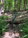
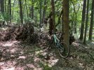
Trails are in good shape (except for a few usual wet spots) and it is really starting to get overgrown. Also ran into a couple of downed trees that should be pretty easy to remove with a saw.
Attachments
I cut a bunch from the Foran field last weekend. Not sure how the rest is. Report back if you go.Anyone been recently? Thinking of going today. Anything to avoid bc of wetness or overgrowth?
Conditions good and Foran was good. "Old side" definitely needs a haircut. We rode Flatlands and Chips mostly. No major trees except at the way north/bottom of Chips near a rock feature. Looks like it's been cut thru on one side and then someone gave up. Face hovering gnats and humidity were brutal today.
SAM
Well-Known Member
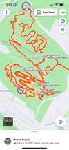
Recent map with info.Quick question, I have not been here in a few years, but I am going to be in the area tomorrow so am considering riding the trails.
I heard about some of the trails closures etc.. is there anything I should be aware of?
Trailforks shows what's closed (it's the northern half of Springside). Well, at least on my phone it did. Desktop shows different but it's basically the X section as far as i know:
View attachment 264681
it will show closed (dimmed out) if set to MTB/emtb (at least it is supposed to)
"All dotted trails are hiking only by order of NJ Dept of Environmental protection." Is this accurate? I thought the closure was due to a deed restriction.
DEP holds the deed if I recall.
They are enforcing the restriction and the town would lose access if they didn't comply.
They are still working towards a resolution.
trener1
Well-Known Member
So based in this map you can't ride from the Upper (which is where I used to park) to the lower section?Recent map with info.
View attachment 264682
SAM
Well-Known Member
Have to use the "Springside Field" (Pink on map) to be legal. Then, Matt's Trail is your connector.So based in this map you can't ride from the Upper (which is where I used to park) to the lower section?
So looking at the official HB trail map @SAM posted, Brogans run appears to be ok for Bikes. Yet on TrailForks it is not. Which is correct?
View attachment 265452
View attachment 265453
Pls send a link to the official map.
I'm too lazy too search.
I'll change it on tf to match
Will defer to @SAM on that. Not sure where he got itPls send a link to the official map.
I'm too lazy too search.
I'll change it on tf to match
SAM
Well-Known Member
I got it from on here. J Short's post. https://www.mtbnj.com/forum/threads/current-trail-map-of-nassau-and-springside-trails.58664/Pls send a link to the official map.
I'm too lazy too search.
I'll change it on tf to match
I believe Brogan's Run is open to MTB.
This is from the Bike Hunterdon Facebook page - which also has a route going right through the closed section.
I haven't been up there in a bit (or anywhere) - are there 'no bikes' signs at the appropriate places?
I'm going to change it on TF, and reach out to our contact - It is probably wrong, since the perimeter trail around it is hiking only.
This creates a problem in TF - I think there may be a trail missing.
One of the trails needs to be split - so a little more work to do.
Last edited: