


You are using an out of date browser. It may not display this or other websites correctly.
You should upgrade or use an alternative browser.
You should upgrade or use an alternative browser.
Camp Cromwell property
- Thread starter Kirt
- Start date
qclabrat
Well-Known Member
Did loops around here today and I'm blown away by all the new trails every few weeks. @jdog and @Kirt is turning a blank canvas into a destination park. I don't think I'll need to visit 6mr anymore for flow. The refreshed trail from the back of the courts (fireplace) to the Vossler trailhead is a one mile downhill which just made me smile. Fine work gentlemen!

I’m excited to be able to do full days of work here in the fall/we’ve just really started and there’s so much we can do hereDid loops around here today and I'm blown away by all the new trails every few weeks. @jdog and @Kirt is turning a blank canvas into a destination park. I don't think I'll need to visit 6mr anymore for flow. The refreshed trail from the back of the courts (fireplace) to the Vossler trailhead is a one mile downhill which just made me smile. Fine work gentlemen!
View attachment 241083
Hottest day of the year? Not a problem. 12 of the team plus 6 team friends (Rob, Rob, Tim, Ryan, Keith, and Wayne) showed up on what was probably the hottest morning of the year to help make the Cromwell trails even better. We did a lot of finishing work today.
Thanks to my awesome team, and the friends of the team, who all came out today to kick some ass.
This place is getting better by the week.


Thanks to my awesome team, and the friends of the team, who all came out today to kick some ass.
This place is getting better by the week.
Red Mosquito
Formerly RLB the Scrapple Boy
Looks like we got the "intense downpour" option last night, about 1.5 inches.
Hopefully most of the dirt is where we left it!

Hopefully most of the dirt is where we left it!
Rode it this morning. The rocks were sweating more than me, but the trails are good to go.Looks like we got the "intense downpour" option last night, about 1.5 inches.
Hopefully most of the dirt is where we left it!
View attachment 241191
rjr44
Well-Known Member
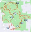
Sooo, been meaning to get out to Cromwell w/ plenty of time just to roll around and figure out the best routing for the most fun (i.e. easiest climbing and mostly fun downhill). I finally got around to it today so here are my notes:
When this place finally opens and if we can park in the lot by the basketball courts it would be pretty damn easy to tailgate there all day doing various loops. It's almost bike park-like, as much as you can get at CR at least. Can even peddle up Vosseler to Miller Lane to take a bombing run down High Tech and then Main Vein.

- First, other than it no longer being dusty and instead being quite tacky, can't tell we got a good dump of rain yesterday
- The work done yesterday morning held up really nice
- Screenshot below is what I did today. I rode over from Gilbride lot but didn't include that in the screenshot (tho it is included in the stats at the bottom)
- The BLACK line is the "climbing trail" using the gravel path, a straightforward climb. Up near the top I made a right onto the pavement instead of a left to stay on gravel. Either way, it ends up at the bottom of the HOOPS connector, in the future I'll stay on the gravel.
- The RED line is the most pedal-y but still mostly downhill, a good warm-up.
- ORANGE is the shortest line but is very fun, fast, and flowy.
- GREEN is a bit longer and also fun, fast, and flowy.
- PURPLE is the longest, fastest, most fun downhill.
When this place finally opens and if we can park in the lot by the basketball courts it would be pretty damn easy to tailgate there all day doing various loops. It's almost bike park-like, as much as you can get at CR at least. Can even peddle up Vosseler to Miller Lane to take a bombing run down High Tech and then Main Vein.
Sooo, been meaning to get out to Cromwell w/ plenty of time just to roll around and figure out the best routing for the most fun (i.e. easiest climbing and mostly fun downhill). I finally got around to it today so here are my notes:
Purple was quite fast already, and with the rain and yesterday's trail work got even faster. The berms made yesterday do need to firm up, they are brand new, so I didn't ride higher up on them.
- First, other than it no longer being dusty and instead being quite tacky, can't tell we got a good dump of rain yesterday
- The work done yesterday morning held up really nice
- Screenshot below is what I did today. I rode over from Gilbride lot but didn't include that in the screenshot (tho it is included in the stats at the bottom)
- The BLACK line is the "climbing trail" using the gravel path, a straightforward climb. Up near the top I made a right onto the pavement instead of a left to stay on gravel. Either way, it ends up at the bottom of the HOOPS connector, in the future I'll stay on the gravel.
- The RED line is the most pedal-y but still mostly downhill, a good warm-up.
- ORANGE is the shortest line but is very fun, fast, and flowy.
- GREEN is a bit longer and also fun, fast, and flowy.
- PURPLE is the longest, fastest, most fun downhill.
When this place finally opens and if we can park in the lot by the basketball courts it would be pretty damn easy to tailgate there all day doing various loops. It's almost bike park-like, as much as you can get at CR at least. Can even peddle up Vosseler to Miller Lane to take a bombing run down High Tech and then Main Vein.
View attachment 241246
It's there a short track race loop for future fun?
It's there a short track race loop for future fun?
I’d be incredibly hesitant to obliterate years of trail building if/when we have shit weather during an event. We are pouring a metric shit ton of sweat equity into building these so I’d be opposed to it, personally.
@rjr44 - are you saying you climbed that middle shot 4x and did 4 separate DH/ish runs?
hls811
Well-Known Member
I’ve been trying to figure out the same, this seems to hit everything.
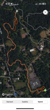
1.Come in off Brookside, take the gravel up - at the split, I go left down and around the empty lot/pile o’ dirt and then up to the basketball courts.
2. Cut in below the courts and then a left to start down.
3. Follow the flow and stay right at the first fork, get the outer loop.
4. It wraps back around, cross the small concrete bridge, make a right and then cut across the field to the middle flow area. Take that down to the gravel road.
5. Climb the lower gravel road back up to the grey shed, make a right and get the lower flow, which will wrap around to the old drainage area,
6. Climb back up to the top, get to the same intersection you were at at #2 - behind the basketball courts.
7. Seven. Seven. ✋🏼✌🏼 enjoy the best mile of riding in central Jersey.
Attachments
rjr44
Well-Known Member
Yessir, 2 climbs all the way up, the other two only halfway at most.I’d be incredibly hesitant to obliterate years of trail building if/when we have shit weather during an event. We are pouring a metric shit ton of sweat equity into building these so I’d be opposed to it, personally.
@rjr44 - are you saying you climbed that middle shot 4x and did 4 separate DH/ish runs?
Just to add, the gravel path is NOT on Trailforks which is why it wasn’t obvious from the onset.
Ok so to level set:
- Smallest run down that starts at the shed is called: The Shed Trail
- Just above that with the stop sign: The Hump Trail
- The best mile in central jersey is really 2 trails:
- The top I refer to the Magic Johnson All Star Loop. Some might call it the Basketball Loop/Trail
- After the pavement crossing it's the Western Trail
- The stuff on the east/southeast side does not have a name yet because we have not fixed them properly. Though you can call #6 on the map in the post above The Chimney Trail if you like, since there's a big stone chimney there
- We do not yet have a way to reference the northeast area on the map above (#3). We need something of note to happen there. Actually, when we worked there, we found a bunch of golf balls. If anyone has ridden there in the last 2 days you may have noticed a golf ball lodged into the trail, which pretty much tells me the dude in the house across the way blasts golf balls into the park still. And so, The Golf Ball Loop was born.
Last edited:
Yessir, 2 climbs all the way up, the other two only halfway at most.
Ok, this probably begs the question of us putting in a climbing trail up the gut then. Ideally, it would be best to get all of us off the paved and/or gravel stuff. Something to keep in mind for future consideration.
So which is the best mile? I'm probably going up that, e-bike and all.Ok so to level set:
- Smallest run down that starts at the shed is called: The Shed Trail
- Just above that with the stop sign: The Hump Trail
- The best mile in central jersey is really 2 trails:
- The top I refer to the Magic Johnson All Star Loop. Some might call it the Basketball Loop/Trail
- After the pavement crossing it's the Western Trail
- The stuff on the east/southeast side does not have a name yet because we have not fixed them properly. Though you can call #6 on the map in the post above The Chimney Trail if you like, since there's a big stone chimney there
- We do not yet have a way to reference the northeast area on the map above (#3). We need something of note to happen there. Actually, when we worked there, we found a bunch of golf balls. If anyone has ridden there in the last 2 days you may have noticed a golf ball lodged into the trail, which pretty much tells me the dude in the house across the way blasts golf balls into the park still. And so, The Golf Ball Loop was born.
hls811
Well-Known Member
Starting behind the basketball court, all the way down to Brookside.So which is the best mile? I'm probably going up that, e-bike and all.
Attachments
So which is the best mile? I'm probably going up that, e-bike and all.
Not my assessment, just quoting the other post.
Red Mosquito
Formerly RLB the Scrapple Boy
Do we know who the trailforks admin is? It would be nice to get this stuff "on the map".Ok so to level set:
- Smallest run down that starts at the shed is called: The Shed Trail
- Just above that with the stop sign: The Hump Trail
- The best mile in central jersey is really 2 trails:
- The top I refer to the Magic Johnson All Star Loop. Some might call it the Basketball Loop/Trail
- After the pavement crossing it's the Western Trail
- The stuff on the east/southeast side does not have a name yet because we have not fixed them properly. Though you can call #6 on the map in the post above The Chimney Trail if you like, since there's a big stone chimney there
- We do not yet have a way to reference the northeast area on the map above (#3). We need something of note to happen there. Actually, when we worked there, we found a bunch of golf balls. If anyone has ridden there in the last 2 days you may have noticed a golf ball lodged into the trail, which pretty much tells me the dude in the house across the way blasts golf balls into the park still. And so, The Golf Ball Loop was born.
I applied, but I'm assuming there is already someone handling it.
Oh yea. Climbed that every time I've ridden there.Starting behind the basketball court, all the way down to Brookside.
I bear right after crossing Brookside and go up.