


You are using an out of date browser. It may not display this or other websites correctly.
You should upgrade or use an alternative browser.
You should upgrade or use an alternative browser.
Wildcat Ridge WMA Conditions
- Thread starter graveyardman67
- Start date
huffster
Well-Known Member
It’s there. It is on Trailforks. I took it up once from behind the building on School Rd. That definitely seemed like the wrong choice. It’s challenging. I never tried it the other way, but imagine it’s still challenging that way too - coming from Snake hill road.Anyone know of anything down over on the south side of GPR? The Way and Ore Deal?
I believe he was just asking if there are any down trees on those trails.....not if they existIt’s there. It is on Trailforks. I took it up once from behind the building on School Rd. That definitely seemed like the wrong choice. It’s challenging. I never tried it the other way, but imagine it’s still challenging that way too - coming from Snake hill road.
View attachment 225894
It’s there. It is on Trailforks.
I think the question was "are there any trees down over there?" and not "are there any trails over there?" 😘
It’s there. It is on Trailforks. I took it up once from behind the building on School Rd. That definitely seemed like the wrong choice. It’s challenging. I never tried it the other way, but imagine it’s still challenging that way too - coming from Snake hill road.
View attachment 225894
He was asking about trees down or similar tm issues. Considering he lives right there and can help out with maintenance
I believe he was just asking if there are any down trees on those trails.....not if they exist
I think the question was "are there any trees down over there?" and not "are there any trails over there?" 😘
weirdHe was asking about trees down or similar tm issues. Considering he lives right there and can help out with maintenance
huffster
Well-Known Member
Ah-hah. That makes sense now that I re-read it.I think the question was "are there any trees down over there?" and not "are there any trails over there?" 😘
Where were hunters in mine hill?Ugh, hunting season. After seeing signs of hunters in Mine Hill and Wildcat (yeah, I know, we're supposed to ride on Sundays only there in hunting season), I did Liffy Island area today.
Ya I dont think hunting is allowed in DMR....and if it is, nobody is hunting there because the deer are the size of elkWhere were hunters in mine hill?
But yes, both directions are tough climbs.It’s there. It is on Trailforks. I took it up once from behind the building on School Rd. That definitely seemed like the wrong choice. It’s challenging. I never tried it the other way, but imagine it’s still challenging that way too - coming from Snake hill road.
View attachment 225894
I see trucks parked on Meriden near the Beach Glen Trail and also the Righter Mine / Koehler Trails. Yes Sundays, otherwise if your traveling through, after 10am, before 3pm, after 6:30pm ( clocks change soon)Ugh, hunting season. After seeing signs of hunters in Mine Hill and Wildcat (yeah, I know, we're supposed to ride on Sundays only there in hunting season), I did Liffy Island area today.
notcho
Well-Known Member
On yellow halfway between dam and road. Right next to the rock work that was done a few years ago.reports of "downfall" can be reported here ...thankyou
Ashcor
Well-Known Member
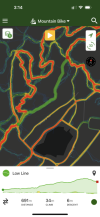
Not technically Wildcat but cleaned up the “low line” (trailforks name) trail on the west side of Telemark AKA “Mildcat”.
With this trail cleaned up it’s now possible to do a full loop on that side without doubling back on trails from either the Lake Ames lot or Hudsonia fields lots.
Lowline goes from the end of Girlscout Cookies just before it turns downhill to the river to the bottom of Evergreen.
Enjoy….
With this trail cleaned up it’s now possible to do a full loop on that side without doubling back on trails from either the Lake Ames lot or Hudsonia fields lots.
Lowline goes from the end of Girlscout Cookies just before it turns downhill to the river to the bottom of Evergreen.
Enjoy….
Attachments
Thank you! I do that Telemark side loop pretty regularly and Low Line is always a cluster. I either lose the trail or there are trees downNot technically Wildcat but cleaned up the “low line” (trailforks name) trail on the west side of Telemark AKA “Mildcat”.
With this trail cleaned up it’s now possible to do a full loop on that side without doubling back on trails from either the Lake Ames lot or Hudsonia fields lots.
Lowline goes from the end of Girlscout Cookies just before it turns downhill to the river to the bottom of Evergreen.
Enjoy….
Ashcor
Well-Known Member
Yeah honestly I couldn’t find where it actually joined into Girlscout Cookies So I cut in a new trail head. Lots of deadfall in that area.Thank you! I do that Telemark side loop pretty regularly and Low Line is always a cluster. I either lose the trail or there are trees down
kaitlyn
Well-Known Member
Where is girlscout cookies? I can't find it on trailforks. thx.On the Telemark side:
Monga and I cleared downed trees from shotgun and the big tree canopy that was down on Girlscout Cookies. Also leaf blew the deep stuff on Iron Spirit cliff side section.