


stilluf
Well-Known Member
On the official map there’s a marked trail on Red, it connects from the left(east) uphill to lower trail (ie along reservoir). I’ve been looking for it, today I found it. It’s marked, but looks like an old fire road blocked by multiple tree blow downs.
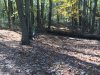
The pic below is from lower red looking uphill (south)
This is a great opportunity to get a ‘new’ trail at CR. It would need a substainable re-route, and some tree clearing. But definitely doable.
The pic below is from lower red looking uphill (south)
This is a great opportunity to get a ‘new’ trail at CR. It would need a substainable re-route, and some tree clearing. But definitely doable.
")