


You are using an out of date browser. It may not display this or other websites correctly.
You should upgrade or use an alternative browser.
You should upgrade or use an alternative browser.
Stephens Map
- Thread starter Stratocaster
- Start date
littlebitplus
New Member
As I've been riding I've been coming across the blazing and wondered if there was a map putting it all together. This is great, thanks. Appreciate all the work you're putting into the park.
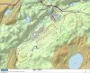
Were you able to put up a higher resolution map? This is good, but parts do get blurry when you zoom in on them.
I know some of the trails are up on motionbased as well as I found and use the one going around Tilcon Lake. Are there others up there as well?
Again, thanks.
Were you able to put up a higher resolution map? This is good, but parts do get blurry when you zoom in on them.
I know some of the trails are up on motionbased as well as I found and use the one going around Tilcon Lake. Are there others up there as well?
Again, thanks.
littlebitplus
New Member
The way I view it, and not saying it's a true representation, but just from riding in there, is that there are two levels to SSP. I ride a bunch of trails at the 1050 - 1200 foot range, and have a great time. I ride a bunch of the trails at the 650 - 800 foot range, and have a great time. And sometimes, I have to go between the two. And that can be a bit of a drag. Rode on Sunday, starting out from near Waterloo, was going along for and hour 20 in the 650 - 820 range, then spent the next 20 minutes (walking some as I'm out of shape ") going up to 1140. Rode there for a half hour, then came back down to the 700- 800 range. Where as the week before, I rode for an hour and a half at the 1100 foot range and had a fine time. That's coming in from more the ITC side.
going up to 1140. Rode there for a half hour, then came back down to the 700- 800 range. Where as the week before, I rode for an hour and a half at the 1100 foot range and had a fine time. That's coming in from more the ITC side.
Again, not a complete representation, as the white trail for example can span the two realms, and there are other trails that do the same, but just from riding it there, that's how I view it. So I pick and choose which side I come in on, and, if I'm in the mood to span the two, when I pick the path I'm riding.
going up to 1140. Rode there for a half hour, then came back down to the 700- 800 range. Where as the week before, I rode for an hour and a half at the 1100 foot range and had a fine time. That's coming in from more the ITC side.Again, not a complete representation, as the white trail for example can span the two realms, and there are other trails that do the same, but just from riding it there, that's how I view it. So I pick and choose which side I come in on, and, if I'm in the mood to span the two, when I pick the path I'm riding.
Keep exploring, I went today by starting at the ranger station and stayed low until rt80 then climbed unmarked to the back power lines worked over to green and back on upper white traversed until orange where you go right for the sickest downhill mooch has to offer=time 2.5 hrs. of killer SS leg burning glory.....MBF
The Kalmyk
Well-Known Member
Hey Matt...Isnt there an entrance from Budd Lake??? That must add some miles of trails ....
Hey Matt...Isnt there an entrance from Budd Lake??? That must add some miles of trails ....
Yes but I end up riding by it, my ride today pretty much covered the entire park maybe about 15-18 miles give or take, easly can add to it also with lollipoping pink and adding blue. There are a bunch of unmarked trails to explore. Spence you say when and we will hit it and bring your climbing legs cuz theres plenty....MBF
The Kalmyk
Well-Known Member
Yes but I end up riding by it, my ride today pretty much covered the entire park maybe about 15-18 miles give or take, easly can add to it also with lollipoping pink and adding blue. There are a bunch of unmarked trails to explore. Spence you say when and we will hit it and bring your climbing legs cuz theres plenty....MBF
Im thinking two Sundays out...Early start 6 am...August 2nd
Im thinking two Sundays out...Early start 6 am...August 2nd
Perfect it's a date
Would you guys mind a tag-a-long if you do this?
that's pretty much my pace. i mean hell, i did race in sport SS!
ok, it was once. and i came in DFL. but i did finish. i did much better in the SS-a-pooloza. i would have been better but i blew a gasket when i couldn't track my calorie intake.
which reminds me, where is my pint glass?
ok, it was once. and i came in DFL. but i did finish. i did much better in the SS-a-pooloza. i would have been better but i blew a gasket when i couldn't track my calorie intake.
which reminds me, where is my pint glass?
The Kalmyk
Well-Known Member
"Get up Jake its late in the morning, the rain is pouring, we got work to do."
The Band
The Band
littlebitplus
New Member
At the start of the green trail (and likely others, I just know it's at that one) is a map of Stephens with colored trail markings, put out by an individual, NJDEP, Chain Gang Mountain Bike Club, and JORBA. Does anyone know where/how one could get a copy of that map?
littlebitplus
New Member
They are, but, they're not the same ones. This was a good quality, color coded with milage, etc, just was a nice one. The ones from the Park office are okay, but just thought it might be possible to get ahold of one of these other ones.
syncroscat
New Member
This is a private map with the blazed trails included.
Let me know if I can post a higher resolution map.
Thanks
Steve
Steve, is this still the best map of Stephens? Really liked the trails you've worked on. Thanks for your efforts.