


You are using an out of date browser. It may not display this or other websites correctly.
You should upgrade or use an alternative browser.
You should upgrade or use an alternative browser.
Sourland Mountain Trail Directory
- Thread starter Jason
- Start date


source: http://somersetcountyparks.org
Attachments

one piece crank
1pc Cranky
What is trail "9" like, and does it actually connect to Belle Mead Bloomsburg road?
Tom P.
Tom P.
J-Dro
Well-Known Member
What is trail "9" like, and does it actually connect to Belle Mead Bloomsburg road?
Tom P.
It's a wide, mostly flat doubletrack trail. It does end on Rt 601 at the yellow gate. It's usually very muddy with some deep puddles after a rain.
J-Dro
Well-Known Member
nice jeff! how long until the "top" end of 3 amigos cross the pipeline and connects to the boulderama area?
Coming May 22, 2010
This is like a big budget movie teaser. Details to follow.
so the extra time spent on saturday was well worth it! nice!
Pearl
THIS CHANGES EVERYTHING
Here is a GPS file I found from 2009 and followed yesterday. Still seems like a decent route. Can anyone tell me what I rode?
http://connect.garmin.com/activity/195684027
http://connect.garmin.com/activity/195684027
J-Dro
Well-Known Member
Here is a GPS file I found from 2009 and followed yesterday. Still seems like a decent route. Can anyone tell me what I rode?
http://connect.garmin.com/activity/195684027
You rode the usual lower trails clockwise, then picked up the red trail (3 Amigos) off the pipeline down to Roaring Rocks, then repeated a section of the white trail, and finished off with Boulderama. You missed the newer section of the red trail that meets up with the white trail just before Boulderama starts. Some of the Sourlands trail crews' finest examples of rock armoring is in that section.
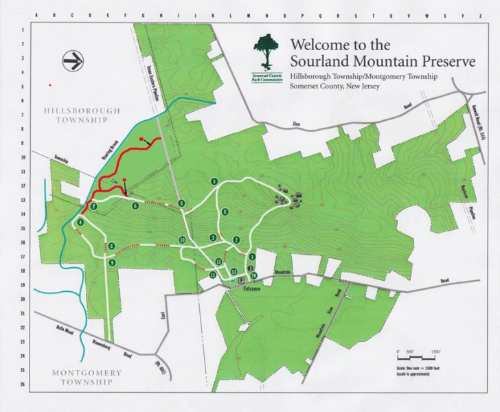
Link above takes you to the 2012 Map. This is the link to the 2015 Map. Only difference is the "new" one has a QR code to get it on your phone. They don't stock paper maps at the trailhead kiosk anymore, they just tell you to scan the QR code. Trail gets very crowded with hikers on the weekends, especially on the Devil's Half Acre side - please be courteous and get out early or during the week if you want to reduce your number of stops.
Best direction to ride the trails is a big perimeter loop going Clockwise starting on the grass slope above the parking lot pond. Full loop takes you in order through Markers 13-12-11-10-9-8-7-(6 optional)-4-Devil's Half Acre-1. This will be approximately 6 tough technical miles with 650ft. elevation gain.
New Blue circle trail Chunky Monkey is not on the map but it is an 0.7 mile offshoot from the Red Three Amigos trail (called Roaring Brook on the official map) between Roaring Rocks and the TX Eastern Pipeline. I will work with the new park management to get the map updated. I doubt they will rename the trails to what the mountain bikers call them though, so here's a rough reference to eliminate confusion:
Marker 8 to 7 = New Shoes (on Strava)
Red circle from Roaring Rocks to TX Eastern Pipeline = Three Amigos
Red from TX Eastern Pipeline to Marker 4= Montezuma
White from Marker 4 to Marker 1 through Devil's Half Acre = Boulderama
Last edited:
rick81721
Lothar
Link above takes you to the 2012 Map. This is the link to the 2015 Map. Only difference is the "new" one has a QR code to get it on your phone. They don't stock paper maps at the trailhead kiosk anymore, they just tell you to scan the QR code. Trail gets very crowded with hikers on the weekends, especially on the Devil's Half Acre side - please be courteous and get out early or during the week if you want to reduce your number of stops.
Best direction to ride the trails is a big perimeter loop going Clockwise starting on the grass slope above the parking lot pond. Full loop takes you in order through Markers 13-12-11-10-9-8-7-(6 optional)-4-Devil's Half Acre-1. This will be approximately 6 tough technical miles with 650ft. elevation gain.
New Blue trail Chunky Monkey is not on the map but it is an 0.7 mile offshoot from the Red Three Amigos trail (called Roaring Brook on the official map) between Roaring Rocks and the TX Eastern Pipeline. I will work with the new park management to get the map updated. I doubt they will rename the trails to what the mountain bikers call them though, so here's a rough reference to eliminate confusion:
Marker 8 to 7 = New Shoes (on Strava)
Red from Roaring Rocks to TX Eastern Pipeline = Three Amigos
Red from TX Eastern Pipeline to Marker 4= Montezuma
White from Marker 4 to Marker 1 through Devil's Half Acre = Boulderama
I would also note that most hikers/runners go in the opposite direction, i.e. counter-clockwise, so especially on weekends when it's crowded, be careful going down the mountain from "devils half-acres boulders" to the parking lot. Also, it's a pity they won't let us build new trails north of devils half-acres - all the land along the ridge that is high and dry
Good point about the hikers, Rick.I would also note that most hikers/runners go in the opposite direction, i.e. counter-clockwise, so especially on weekends when it's crowded, be careful going down the mountain from "devils half-acres boulders" to the parking lot. Also, it's a pity they won't let us build new trails north of devils half-acres - all the land along the ridge that is high and dry
Who said they won't let us build trails out that way? I'm not aware of anyone ever asking or willing to take on such a big project. We certainly have a good loop going now but more mileage would be nice. Something we might be able to pursue with the new Parks management in the future, but there are still a few projects on the existing trails to complete first.
rick81721
Lothar
Good point about the hikers, Rick.
Who said they won't let us build trails out that way? I'm not aware of anyone ever asking or willing to take on such a big project. We certainly have a good loop going now but more mileage would be nice. Something we might be able to pursue with the new Parks management in the future, but there are still a few projects on the existing trails to complete first.
IIRC Jeff said the previous "approver of new trails" lived on E Mountain rd and for some reason didn't want new trails heading in his direction.
OK, well he doesn't work there or live there anymore so we'll see.IIRC Jeff said the previous "approver of new trails" lived on E Mountain rd and for some reason didn't want new trails heading in his direction.
I'm definitely a little lacking on the technology side, but just to give everyone a heads-up, I am now the Sourlands admin on Trailforks and trails are finally being added as I type this (thanks @skiphreaknj whoever that is!). I am just confirming everything from him right now but will hopefully be able to edit later because some names/difficulties are a little off to me. Bear with me because i am still leaning. Once i get all the trails sorted out, maybe @Patrick could set up the trail condition widget for us here. I'll keep everyone posted.