


You are using an out of date browser. It may not display this or other websites correctly.
You should upgrade or use an alternative browser.
You should upgrade or use an alternative browser.
New High Mountain Trail Map
- Thread starter ElPablo
- Start date
TK421
New Member
Thank you ElPablo! This is a game changer for me. I can’t ride this place without Maprika and your map takes the cake. Really appreciate the climb, berm and rock garden markers, although imho the whole place is one giant rock garden.
High mountain has a way of getting under your skin. She’s a cruel mistress who always lures me back for more abuse. Still can’t make it up the steep switchbacks on the south face off the summit of deer pen (3) without several dismounts and loud profanity, yet I know I’ll try again someday. In the meantime I have a better sense of what I’m getting into when I explore the other trails.
Outstanding work. Thanks again.
Paul H
Fearless OOS Poser
You hush and just help me with what I texted you with 😛This one time, I saw a guy being helped down with a broken leg on Wild Turkey. Just sayin'.
ElPablo
Member
Thank you ElPablo! This is a game changer for me. I can’t ride this place without Maprika and your map takes the cake. Really appreciate the climb, berm and rock garden markers, although imho the whole place is one giant rock garden.
High mountain has a way of getting under your skin. She’s a cruel mistress who always lures me back for more abuse. Still can’t make it up the steep switchbacks on the south face off the summit of deer pen (3) without several dismounts and loud profanity, yet I know I’ll try again someday. In the meantime I have a better sense of what I’m getting into when I explore the other trails.
Outstanding work. Thanks again.
I’m glad my map is helping you discover High Mountain - I’ll be updating the map soon with several new trails !
ElPablo
Member
Another excellent alternative to the great Maprika map is the Trailforks app:
https://www.trailforks.com/region/high-mountain-15020/
Mine’s a lot prettier AND you can install it on Garmin Edge bike computers - hah ! And it prints beautifully on waterproof paper 🙂
ElPablo
Member
Hey everyone, I just uploaded the latest updates to the map, v1.0.4. I added a few new trails, made a few corrections and cleaned up the legend.
http://paulsmaps.com/high-mountain-trail-map/
http://paulsmaps.com/high-mountain-trail-map/
RobSinger
New Member
Hi. I don't see the site the map was at available anymore, is there another way to get a copy of the pdf version?Hey everyone, I just uploaded the latest updates to the map, v1.0.4. I added a few new trails, made a few corrections and cleaned up the legend.
http://paulsmaps.com/high-mountain-trail-map/
Zaskar
Well-Known Member
Hi. I don't see the site the map was at available anymore, is there another way to get a copy of the pdf version?
Not sure if this is the same but Trailforks has it.
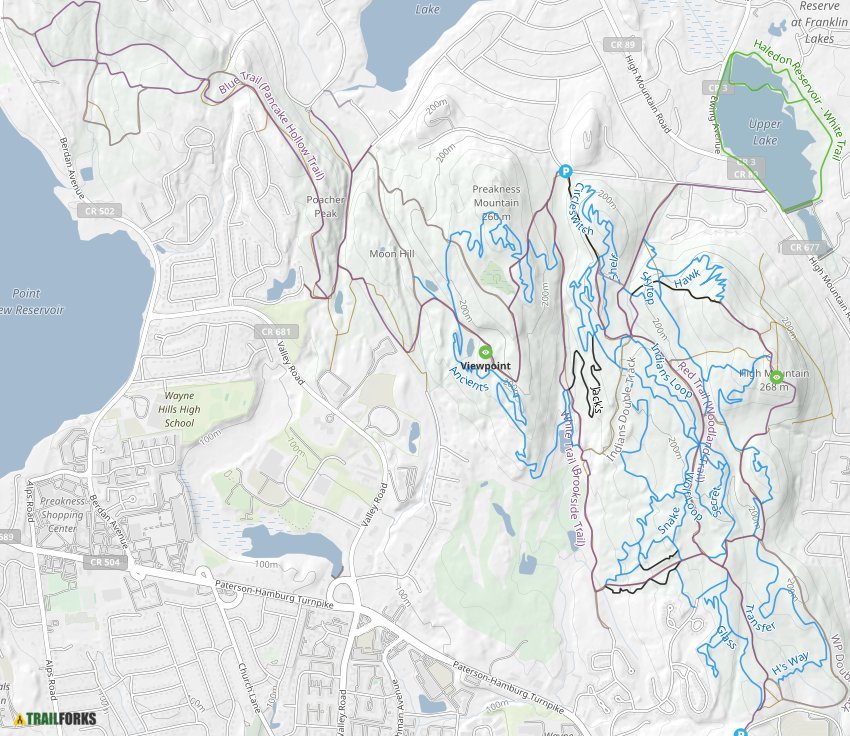
High , Wayne on Trailforks
High Mountain Park PreserveHigh Mountain Park Preserve is owned by Wayne Township, The Nature Conservancy and State of New Jersey, and was established in 1993.
RobSinger
New Member
Thank you. I saw that one on Trailforks too but it doesn't have the trail legend.Not sure if this is the same but Trailforks has it.
High , Wayne on Trailforks
High Mountain Park PreserveHigh Mountain Park Preserve is owned by Wayne Township, The Nature Conservancy and State of New Jersey, and was established in 1993.www.trailforks.com
@RobSinger - please consider finding it your HW assignment!! 🙂
Let us know - and see ya out there.
thanks!
Let us know - and see ya out there.
thanks!
Not the original and there is a more update version - the H's Way trail is missing, but it's visible and can be expanded and zoomed in.
July 2017. not bad.
there are maps on maprika.
send in someone to update!!!