Ramblings from Moe Mountain

Kaleidopete

Well-Known Member

Attachments

  • WarwickATCommunity_063012_Map-Color-HR.jpg
    WarwickATCommunity_063012_Map-Color-HR.jpg
    163.7 KB · Views: 244

jimf

Active Member
I ride hickory quite a bit, its basically my backyard. Pete, you missed most of the trails there by crossing the field, there is a decent loop that goes right around both fields and brings you back down to the golf cart path. if you park at the park and ride you can get your legs warmed up climbing the road. On the map below, park at red arrow, climb the road toward the golf course and bear right where I have the red line(not sure why this road does not show on the map) The red line is a road that forks, one way up and down, when it comes back together the trail head is on the left side and pretty obvious(marked in yellow) you can pretty much find the entire loop by following along from this point and avoiding any forks that are not traveled. You can also park at the blue arrow but its best to get your legs warmed up coming from the parking lot, the park has quite a bit of climbing. I can show you the whole loop if interested. its only about 8 miles of trail total but the first climb out from the parking lot is about 450ft of elevation gain in the first mile and is a leg burner

Screen Shot 2016-09-01 at 6.17.31 AM.png
 

Kaleidopete

Well-Known Member
I ride hickory quite a bit, its basically my backyard. Pete, you missed most of the trails there by crossing the field, there is a decent loop that goes right around both fields and brings you back down to the golf cart path. if you park at the park and ride you can get your legs warmed up climbing the road. On the map below, park at red arrow, climb the road toward the golf course and bear right where I have the red line(not sure why this road does not show on the map) The red line is a road that forks, one way up and down, when it comes back together the trail head is on the left side and pretty obvious(marked in yellow) you can pretty much find the entire loop by following along from this point and avoiding any forks that are not traveled. You can also park at the blue arrow but its best to get your legs warmed up coming from the parking lot, the park has quite a bit of climbing. I can show you the whole loop if interested. its only about 8 miles of trail total but the first climb out from the parking lot is about 450ft of elevation gain in the first mile and is a leg burner

View attachment 40151
Great Info, sure, show me the whole loop. GPX file?
I now one trail goes down and across a stream and then up a hill, on the right side of the fields when riding in from parking.
 

jimf

Active Member
Alternatively we can just meet and I can show you the trails. You did find the connector that takes you out to cascade road, from there you can go out and do a loop at cascade lake, the area really has great potential
 

Kaleidopete

Well-Known Member
A short ride today to check out the San Cap Park in Hewitt, West Milford.
The county just redid the parking area. This trail goes up along Greenwood Lake.
There are lots of trails going off the main trail. It looks like it's used by motorcycles
and quads too. The off trails look interesting, but they can't go too far because you're
between a mountain and the road along the lake. I turned around because the trail
was getting tougher to see and I'm running out of time today.

Parking
SanCapnew02.jpg


End of trail today
SanCapnew04.jpg


Trail
SanCapnew06.jpg


Behind the ball field
SanCapnew07.jpg
 

huffster

Well-Known Member
Thanks. I went and checked it out today. I definitely found some of the good stuff. Not a real big place, but big enough to have a fun ride. There were still a number of off-shoots that I did not fully explore. So there is more to check out next time.
 

Kaleidopete

Well-Known Member
I had a new friend, Russell call and ask to go riding in Wawayanda.
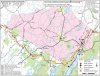
Today was the day we set up. Russell is in his forties and a descent rider, so I picked out a loop I thought would be good for him and torturous for me. He is a great guy because he just wants to get out and ride and my slowness doesn’t bother him at all. I usually plan the ride and send my riding partner out ahead with some instructions and then I catch up at my pace. This way they’re not stuck behind me and can do their thing. Well Russell shows up with his new Farley 9 set up clipless, which is also new for him. He’s thinking ride with Pete and get used to the new things at an easy pace. Beforehand I was thinking I gotta give him some tough stuff to make his ride fun. We did it my way and he had a blast! He was surprised at how quickly he adapted to the new bike and the clipless. I actually heard a few whoops and hollers from up ahead as he tore the tough stuff up. About 2/3 of the way through his shifter was acting up, I could see the chain trying to decide which gear to stay on. We both had a great time out there and came back and had some beer and great conversation. He’s lovin’ his new bike and that’s what it’s all about. Fun on the trails. The last part of my loop had a short un-maintained section I felt I had to apologize for, He kiddingly said "I think maybe you don't want me back again" . The loop we did for those that know the park is Banker trail to Red Dot and over Nature Jim’s Bridge, up the grinding climb, to Double Pond, to Plymouth Trail and back to Banker and home. Sorry no photos, I was too busy catching my breath and catching up.
 

Kaleidopete

Well-Known Member
Not much to write, except,
Crashed on Wingdam trail. I went down falling on my left side, somehow brushing my right palm just below my thumb and scraping my left knee on the left side and straining the muscle in my right leg. Hit my head (helmet) on a hidden downed beach tree. It would have been bad without the helmet. I was riding the Softride bike with skinny tires 2.5’s compared to my 4.8’s on my Farley. This Softride is much harder to ride than my Fatties, it jars the crap outta ya. It’s weird how the gearing feels the same as my other bikes though. This Softride has twist shift with three gears up front and seven in the rear and it shifts smooth as silk. I’ve been getting out every day so far for at least an hour ride to do Utah’s September challenge, 1/4 of the way there. I really like getting out riding early mornings.

soft8th2.jpg
 

Kaleidopete

Well-Known Member
I posted this in the Utah challenge too, but decided to put it here too.
Here is an example of glacial quarrying at Wawayanda, it is a phenomenon that is responsible for the erosion and transportation of individual pieces of bedrock, especially large "joint blocks". As a glacier moves down a valley, friction causes the basal ice of the glacier to melt and infiltrate joints (cracks) in the bedrock. The freezing and thawing action of the ice enlarges, widens, or causes further cracks in the bedrock as it changes volume across the ice/water phase transition (a form of hydraulic wedging), gradually loosening the rock between the joints. This is what the furnace was built with as well as much of the village.

soft10gl.jpg
 

Kaleidopete

Well-Known Member
Well I’ve been riding the Softride bike (shit bike) every day this month making my play for Johnny Utahs September challenge. It hasn’t been easy, I’m used to fatter tires. My other two bikes are a Trek Farley 4.8 tires and a Surly Moonlander 5.02 tires. This Softride has 2.3 tires. I usually ride my fatties at 5-8 psi. These 2.3’s I’ve ridden at 16 psi and found out that’s dangerous. I was advised to go to 45 psi. Holy crap, I’m all over the place! I settled for around 26 psi. I prefer like 24 psi. so I’m figuring it out. It’s a big difference in a few psi I’m finding out. I never rode anything but Fatties with low psi and I never realized how they roll over anything compared to 2.3’s, that bounce off everything. This challenge has been fun learning to ride the Softride, but I can’t wait for it to be over and get back on the Fatties. some photos.
the swamp
soft17th1.jpg


Wingdam trail
Softy wingdam03.jpg


Double Pond trail
Softys 15th01.jpg


da rocks
Softys 14th01.jpg


Black Eagle trail
Softys 12th03.jpg
 
Top Bottom